Old Harbor Reservation Parkways facts for kids
Quick facts for kids |
|
|
Old Harbor Reservation Parkways, Metropolitan Park System of Greater Boston
|
|
 |
|
| Location | Boston, Massachusetts |
|---|---|
| Area | 55.8 acres (22.6 ha) |
| Built | 1893 |
| Architect | Frederick Law Olmsted Arthur Shurcliff |
| MPS | Metropolitan Park System of Greater Boston MPS |
| NRHP reference No. | 08000693 |
| Added to NRHP | July 24, 2008 |
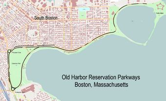
The Old Harbor Reservation Parkways are three special historic roads in the Old Harbor area of Boston, Massachusetts. They are part of a larger system of parkways in Boston, which were designed by a famous landscape architect named Frederick Law Olmsted. These roads help connect different parts of the city and offer beautiful views.
The parkways include:
- William J. Day Boulevard: This road runs all the way from Castle Island to Kosciuszko Circle. It follows the edge of Pleasure Bay and the Old Harbor shoreline.
- Columbia Road: A section of this road starts at Farragut Road and goes west to Pacuska Circle. This part of Columbia Road runs very close to Day Boulevard. It also forms the northern edge of Joe Moakley Park. Another part of Columbia Road, further away, is not part of this parkway system.
- Old Colony Avenue: This road goes from its southern end near Kosciuszko Circle, northward to Pacuska Circle. It forms the western border of Joe Moakley Park. The part of Old Colony Avenue north of Pacuska Circle is not included in the parkway system.
These roads follow the southern coastline of South Boston, starting from Castle Island. They also go around Joe Moakley Park. The southernmost point where these roads meet is Kosciuszko Circle. These important roadways were added to the National Register of Historic Places on July 24, 2008. This means they are recognized for their historical importance.
History of the Parkways
In the 1870s, Frederick Law Olmsted created his famous plans for Boston's "Emerald Necklace" of parks. His idea included connecting Franklin Park to the coastline of South Boston and Dorchester. He imagined a beautiful waterfront park area there.
Early Plans and Challenges
Olmsted first formally suggested the parkland that is now Joe Moakley Park in the 1880s. He also proposed a causeway, which is a raised road across water, to connect Castle Island to the mainland. However, these plans faced delays. One big reason was that Castle Island was still under the control of the federal military.
Because of this, the causeway that opened in 1892 was not fully connected to Castle Island. Instead, it had a drawbridge separating it. The oldest part of the parkways, originally called Gardner Way (now the eastern half of Day Boulevard), opened on this causeway. Castle Island itself wasn't fully connected to the mainland until the 1930s.
Developing the Park and Roads
The development of Joe Moakley Park and the roads around it was part of a bigger plan. This plan aimed to connect Franklin Park with Marine Park, which is at the eastern end of Day Boulevard. The city started acquiring land for these projects in the 1890s.
Old Colony Avenue was built in 1898. It was laid out on what used to be a railroad track. However, the Strandway, which is now the southern part of Day Boulevard, was not finished until the 1920s. Later parts of this large project were designed by Arthur Shurcliff. He was a student and follower of Frederick Law Olmsted.
 | John T. Biggers |
 | Thomas Blackshear |
 | Mark Bradford |
 | Beverly Buchanan |


