
Opémisca Lake facts for kids
Quick facts for kids Opémisca Lake |
|
|---|---|

Watershed of Nottaway River
|
|

Opémisca Lake
Location in Quebec
|
|
| Location | Eeyou Istchee Baie-James |
| Coordinates | 49°55′03″N 74°52′03″W / 49.91750°N 74.86750°W |
| Type | Natural |
| Primary inflows | Chibougamau River, Opémisca River, Leclerc creek, Springer creek, Daubrée creek. |
| Primary outflows | Chibougamau River |
| Basin countries | Canada |
| Max. length | 22.3 kilometres (13.9 mi) |
| Max. width | 14.3 kilometres (8.9 mi) |
| Surface elevation | 358 metres (1,175 ft) |
Opémisca Lake is a large freshwater lake in Quebec, Canada. It is located in the Eeyou Istchee Baie-James area. The lake spreads across several different areas called cantons.
The main activity around the lake is forestry, which means cutting down trees for wood. After forestry, tourism is very important. Many people enjoy visiting the lake for fun activities.
Boating and vacations are popular, especially because the village of Chapais is nearby. You can find several cottages and a beach campground on the shores of West Bay.
It's good to know that Opémisca Lake is usually frozen for a long time. The ice covers the lake from early November until mid-May. However, it's safe to walk or play on the ice from mid-November to mid-April.
Contents
Exploring Opémisca Lake's Geography
Opémisca Lake gets its water from several rivers and creeks. The Chibougamau River flows into the east side of the lake. There's even a bridge over the river for a forest road.
Other rivers and creeks also feed the lake. The Opémisca River and Leclerc Creek flow in from the north. Springer Creek and Daubrée Creek add water from the south.
Size and Shape of the Lake
Opémisca Lake is quite big! It is about 22.3 kilometres (13.9 mi) long. At its widest point, it measures 14.3 kilometres (8.9 mi) across. The lake sits at an elevation of 358 metres (1,175 ft) above sea level.
The lake has a very interesting and uneven shape. Its shoreline stretches for about 148 kilometres (92 mi). It is divided into three main parts, and each part has many bays and peninsulas (pieces of land sticking out into the water).
Many islands are found in the northwestern part of the lake. The biggest island is called "La Grosse Île," which means "The Big Island." It is about 4.2 kilometres (2.6 mi) long.
Nearby Communities and Landmarks
The Cree village of Oujé-Bougoumou is located on the north shore of Opémisca Lake. This village is about 16.3 kilometres (10.1 mi) north of Chapais.
A mountain called the Opemisca sheep is also nearby. It is 541 metres (1,775 ft) tall. This mountain is located about 4.8 kilometres (3.0 mi) northwest of Oujé-Bougoumou village. You'll also find many marshy areas around the lake, especially on the north side.
Lake Connections and Water Flow
Opémisca Lake is connected to other important water bodies. It is about 31.3 kilometres (19.4 mi) west of Chibougamau Lake. On its west side, a passage about 3.5 kilometres (2.2 mi) long connects it to Michwacho Lake.
The water from Opémisca Lake flows out through the Chibougamau River. This river then flows southwest to join the Waswanipi River. The Waswanipi River generally flows west, passing through Lake Waswanipi and Goéland Lake (Waswanipi River).
Understanding the Name: Opémisca
The name "Opémisca" has a long history. In 1905, an official report mentioned "Opamiska" and "Opemiska" as names for this lake. The report from the "Commission Geography of Canada" in 1911 also used "Opémisca." This name is also used for the mountain nearby.
Local Cree people say the word "Opémisca" means "difficult to extirpate." This might refer to something hard to remove or pull out. In another Indigenous language, Innu, the name Opémisca (or Opamiska) means "it is a bit high."
Another idea is that the term "pamiska" in Algonquin means "a place where the lake's edges are dotted with aquatic weeds." This makes sense because the northern part of the lake is quite marshy.
In the past, the lake was also known as "Sandy Straw Lake." This name might have come from an explorer named Henry O'Sullivan in 1901. He suggested "Sandy Beach Lake" as a translation for the lake he called Opamiska.
The name "Lake Opémisca" was officially recognized on December 5, 1968. This happened when the Commission de toponymie du Québec was created.
Images for kids
-
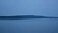
Opémisca Lake viewed from Camping Opémiska

