Orangeville, Ohio facts for kids
Quick facts for kids
Orangeville, Ohio
|
|
|---|---|
|
Village
|
|

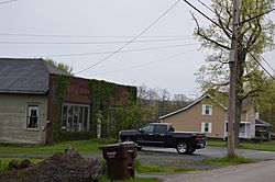
Hartford Street
|
|

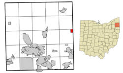
Location of Orangeville in Trumbull County, Ohio.
|
|
| Country | United States |
| State | Ohio |
| County | Trumbull |
| Area | |
| • Total | 1.05 sq mi (2.71 km2) |
| • Land | 0.74 sq mi (1.93 km2) |
| • Water | 0.30 sq mi (0.78 km2) |
| Elevation | 922 ft (281 m) |
| Population
(2020)
|
|
| • Total | 174 |
| • Density | 233.56/sq mi (90.20/km2) |
| Time zone | UTC-5 (Eastern (EST)) |
| • Summer (DST) | UTC-4 (EDT) |
| ZIP code |
44453
|
| Area code(s) | 234/330 |
| FIPS code | 39-58674 |
| GNIS feature ID | 1087042 |
Orangeville is a small village in eastern Trumbull County, Ohio, United States. It is located right on the border with Pennsylvania. In 2020, about 174 people lived there. Orangeville is part of a larger area known as the Youngstown–Warren metropolitan area.
History of Orangeville
Orangeville has had a post office since 1840. This means people have been sending and receiving mail there for a very long time! No one is quite sure how Orangeville got its name. It might have been named after a place called Orange in Connecticut.
Geography of Orangeville
Orangeville is one of the towns farthest east in Ohio. It covers about 1.16 square miles (about 3 square kilometers). Most of this area is land, but a small part is water.
Population Changes
| Historical population | |||
|---|---|---|---|
| Census | Pop. | %± | |
| 1870 | 260 | — | |
| 1900 | 223 | — | |
| 1910 | 185 | −17.0% | |
| 1920 | 222 | 20.0% | |
| 1930 | 223 | 0.5% | |
| 1940 | 265 | 18.8% | |
| 1950 | 367 | 38.5% | |
| 1960 | 397 | 8.2% | |
| 1970 | 268 | −32.5% | |
| 1980 | 223 | −16.8% | |
| 1990 | 253 | 13.5% | |
| 2000 | 189 | −25.3% | |
| 2010 | 197 | 4.2% | |
| 2020 | 174 | −11.7% | |
| U.S. Decennial Census | |||
The population of Orangeville has changed over the years. In 1870, there were 260 people living there. The population grew to its highest point in 1960 with 397 residents. By 2020, the population was 174 people.
See also
 In Spanish: Orangeville (Ohio) para niños

