Oskarshamn Municipality facts for kids
Quick facts for kids
Oskarshamn Municipality
Oskarshamns kommun
|
||
|---|---|---|

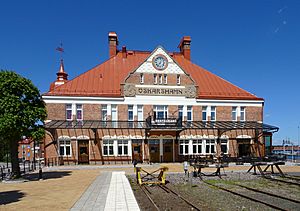
Oskarshamn Railway Station
|
||
|
||
 |
||
| Country | Sweden | |
| County | Kalmar County | |
| Seat | Oskarshamn | |
| Area | ||
| • Total | 2,294.54 km2 (885.93 sq mi) | |
| • Land | 1,054.81 km2 (407.26 sq mi) | |
| • Water | 1,239.73 km2 (478.66 sq mi) | |
| Area as of January 1, 2010. | ||
| Population
(June 30, 2012)
|
||
| • Total | 26,235 | |
| • Density | 11.43366/km2 (29.6131/sq mi) | |
| Time zone | UTC+1 (CET) | |
| • Summer (DST) | UTC+2 (CEST) | |
| ISO 3166 code | SE | |
| Province | Småland | |
| Municipal code | 0882 | |
| Website | www.oskarshamn.se | |
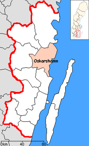
Oskarshamn Municipality (called Oskarshamns kommun in Swedish) is a local area in south-eastern Sweden. It's part of Kalmar County. The main city and administrative center is Oskarshamn.
This municipality was formed in 1967. Three smaller rural areas joined the City of Oskarshamn. In 1971, it became a modern, unified municipality.
In 1966, work began on the first nuclear power plant in the area, called OKG. Since then, two more reactors have been built. Today, this plant creates about 10% of Sweden's electricity. In October 2020, the local council voted to support building a nuclear waste storage site here. The final decision will be made by the Swedish government.
| Top - 0-9 A B C D E F G H I J K L M N O P Q R S T U V W X Y Z |
Oskarshamn's Coat of Arms
Oskarshamn was named after King Oscar I of Sweden. The top part of the coat of arms shows symbols of the King. Other parts of the design show symbols for shipping (an anchor), trade (the staff of Mercury), and wealth (a cornucopia, which is a horn of plenty).
The current design of the coat of arms was made in 1942. It is very similar to the older design. After 1971, this coat of arms was used for the new, larger municipality. The old coats of arms for Döderhult and Misterhult were no longer used.
Towns and Villages
There are nine main urban areas, also known as localities or tätorter in Swedish, in Oskarshamn Municipality.
The table below lists these places by how many people lived there on December 31, 2005. The main city, Oskarshamn, is shown in bold letters.
| # | Locality | Population |
|---|---|---|
| 1 | Oskarshamn | 17,143 |
| 2 | Påskallavik | 1,077 |
| 3 | Kristdala | 994 |
| 4 | Figeholm | 802 |
| 5 | Fårbo | 520 |
| 6 | Mysingsö | 398 |
| 7 | Emsfors 1) | 353 |
| 8 | Bockara | 351 |
| 9 | Saltvik | 285 |
1) A small part of Emsfors is also in Mönsterås Municipality.
Local News and Media
Oskarshamn has two local newspapers. One is called Oskarshamns-Tidningen, which has a more traditional viewpoint. The other is Nyheterna, which has a more social democratic viewpoint.
Interesting Places to Visit
The Blå Jungfrun is a small island located off the coast. It is between the mainland and the island of Öland. This island is protected as a national park.
See also
 In Spanish: Municipio de Oskarshamn para niños
 | James B. Knighten |
 | Azellia White |
 | Willa Brown |


