Ossian, Indiana facts for kids
Quick facts for kids
Ossian, Indiana
|
|
|---|---|
| Town of Ossian | |

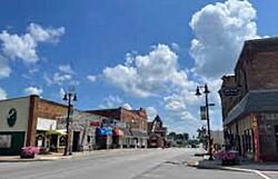
Downtown Ossian
|
|
| Motto(s):
"Handed Down From Generation To Generation"
|
|

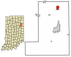
Location of Ossian in Wells County, Indiana.
|
|
| Country | United States |
| State | Indiana |
| County | Wells |
| Jefferson | Jefferson |
| Area | |
| • Total | 1.68 sq mi (4.34 km2) |
| • Land | 1.67 sq mi (4.31 km2) |
| • Water | 0.01 sq mi (0.03 km2) |
| Elevation | 827 ft (252 m) |
| Population
(2020)
|
|
| • Total | 3,266 |
| • Density | 1,960.38/sq mi (757.05/km2) |
| Time zone | UTC-5 (Eastern (EST)) |
| • Summer (DST) | UTC-4 (EDT) |
| ZIP code |
46777
|
| Area code(s) | 260 |
| FIPS code | 18-57168 |
| GNIS feature ID | 2396840 |
| Website | http://www.ossianin.com/ |
Ossian is a small town located in Wells County, Indiana, in the United States. It's part of Jefferson Township. The town got its name from a character named Ossian, who was a storyteller in old poems by a Scottish poet named James Macpherson. In 2020, about 3,266 people lived in Ossian.
Contents
History of Ossian
The first post office in Ossian opened in 1850. Before that, in 1843, a road called Indiana State Road 1 was made useful between Fort Wayne and Bluffton.
Early Roads and Railroads
In 1850, a company was formed to build a "plank road." This was a special type of road made of wooden planks. It was a toll road, meaning people had to pay money to use it, especially if they had horses or horse-drawn vehicles.
Later, in 1869, the Fort Wayne, Cincinnati, & Louisville Railroad was built through Ossian. This railroad started working fully in 1870. Today, this railway is an important route for the Norfolk Southern Corporation, running north and south. Ossian is still served by Indiana State Road 1. Also, a major highway called Interstate 469 is just four miles north of town. The Fort Wayne International Airport is only seven miles south.
The Minion Silo
In 2016, something fun happened near Ossian. A 25-foot tall grain silo on a farm was painted to look like a Minion character from the Despicable Me movies. A Vietnam War veteran had the idea to paint it. After he passed away at age 73, his family and friends painted the silo to remember him. The Minion silo quickly became famous, with many people stopping to see it. It even made national news!
Geography of Ossian
Ossian covers a total area of about 1.68 square miles (4.34 square kilometers). Most of this area, about 1.67 square miles (4.31 square kilometers), is land. A very small part, about 0.01 square miles (0.03 square kilometers), is water.
Population Facts
| Historical population | |||
|---|---|---|---|
| Census | Pop. | %± | |
| 1880 | 522 | — | |
| 1900 | 529 | — | |
| 1910 | 661 | 25.0% | |
| 1920 | 724 | 9.5% | |
| 1930 | 788 | 8.8% | |
| 1940 | 784 | −0.5% | |
| 1950 | 761 | −2.9% | |
| 1960 | 1,108 | 45.6% | |
| 1970 | 1,538 | 38.8% | |
| 1980 | 1,945 | 26.5% | |
| 1990 | 2,428 | 24.8% | |
| 2000 | 2,943 | 21.2% | |
| 2010 | 3,289 | 11.8% | |
| 2020 | 3,266 | −0.7% | |
| U.S. Decennial Census | |||
Population in 2010
According to the 2010 census, there were 3,289 people living in Ossian. These people lived in 1,287 homes, and 909 of these were families. The town had about 2,300 people per square mile.
About 26% of the people in Ossian were under 18 years old. Around 15% were 65 years old or older. The average age in the town was about 37 years old. Slightly more than half of the population (52.4%) was female, and 47.6% was male.
Education in Ossian
The schools in northern Wells County, including Ossian, are part of the Northern Wells Community Schools district. This district runs four schools:
- Ossian Elementary
- Lancaster Elementary
- Norwell Middle School
- Norwell High School
Ossian also has a public library. It is a branch of the Wells County Public Library.
See also
 In Spanish: Ossian (Indiana) para niños

