
Ouareau River facts for kids
Quick facts for kids Ouareau River |
|
|---|---|

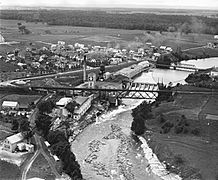
Ouareau River in Saint-Liguori.
|
|
| Country | Canada |
| Province | Quebec |
| Region | Lanaudière |
| Regional County Municipalities | Matawinie Regional County Municipality, Montcalm Regional County Municipality and Joliette Regional County Municipality |
| Physical characteristics | |
| Main source | Lake Ouareau Saint-Donat, Quebec 387 m (1,270 ft) 46°19′02″N 74°07′40″W / 46.317324°N 74.127811°W |
| River mouth | L'Assomption River L'Épiphanie, Quebec (town) 9 m (30 ft) 45°56′24″N 73°24′27″W / 45.94°N 73.4075°W |
| Length | 83.8 km (52.1 mi) |
| Basin features | |
| Tributaries |
|
The Ouareau River is a river in Quebec, Canada. It flows into the Assomption River. This river runs through the Lanaudière region. It passes through several areas, including:
- Matawinie Regional County Municipality (like Saint-Donat and Rawdon)
- Montcalm Regional County Municipality (like Sainte-Julienne and Saint-Liguori)
- Joliette Regional County Municipality (like Crabtree and Saint-Paul)
The river flows near the towns of Chertsey, Rawdon, Saint-Liguori, and Crabtree. Many roads follow the river, making it easy to access. The river usually freezes from mid-December to late March. It's generally safe to walk on the ice from late December to early March. The water level changes with the seasons and how much rain falls.
Contents
Where the Ouareau River Starts

The Ouareau River begins in Saint-Donat. Its source is at a dam on the northeast side of Lake Ouareau. This lake is about 7.6 kilometres (4.7 mi) long and 4.1 kilometres (2.5 mi) wide. It sits at an altitude of 387 metres (1,270 ft).
The lake's mouth is about 14.4 kilometres (8.9 mi) north of Notre-Dame-de-la-Merci. It is also about 50.4 kilometres (31.3 mi) northwest of Rawdon. From its start, the Ouareau River flows for about 83.8 kilometres (52.1 mi).
Rivers and Streams Joining the Ouareau
As the Ouareau River flows, many smaller rivers and streams join it. These include:
- Pagé Creek
- Dufresne River
- Baulne River
- Noir stream
- Beaurivage Creek
- Gour stream
- Trudel River
- Rivière du Nord (Ouareau River)
- Jean-Venne River
- Burton River
- Rouge River
-
A paper factory in Crabtree in 1925

The River's Journey
The Ouareau River's journey can be divided into three main parts:
Upper Part of the River
This section is about 23.0 kilometres (14.3 mi) long.
- It flows northeast in Saint-Donat, passing through Lac Chambord.
- Then it turns southeast, collecting water from Lac Sombre.
- It continues southeast through Notre-Dame-de-la-Merci, where Lafrenière Creek joins it.
- The river crosses an area called Les Cinq Chutes.
- Further southeast, it collects water from several lakes like Lac à l'Île and Lac Prévost. It also gets water from the North River (Ouareau River). This part of the river flows near the Ouareau Forest Regional Park.
Middle Part of the River

This section is about 31.0 kilometres (19.3 mi) long.
- It flows south through Chertsey. Here, the Baulne River and other streams join it.
- It passes around the village of Grande-Vallée.
- The river continues south, with Beaurivage brook and Perreault brook adding water.
- It goes through rapids and falls until the Jean-Venne River joins it.
- More rapids and falls are found before the Burton River flows in.
- The river then enters Rawdon, passing Les Cascades rapids.
- Finally, it crosses Pontbriand Lake, ending at the Rawdon dam in the village.
Lower Part of the River
This final section is about 29.8 kilometres (18.5 mi) long.
- It flows southeast, passing south of Rawdon and under the route 348 bridge.
- It goes through the Parc des Chutes-Dorwin and Manchester Falls.
- For a while, it forms the border between Saint-Jacques and Saint-Liguori.
- It flows under the route 346 bridge in Saint-Liguori.
- The river then goes around Archange-Godbout Island before reaching Crabtree.
- In Crabtree, it passes under route 158.
- The Rouge River joins it from the northwest.
- It flows past the village of Crabtree.
- The river then forms the border between Crabtree and Saint-Paul.
- Finally, it makes a large S-shape to Pointe à Forget, where it joins the Assomption River.
The Ouareau River meets the Assomption River in Saint-Paul. This meeting point is about 11.6 kilometres (7.2 mi) northwest of the St. Lawrence River. It is also about 9.4 kilometres (5.8 mi) south of downtown Joliette.
What's in a Name?
The name "Ouareau" comes from the Algonquin language. It means "in the distance." The official name "Ouareau River" was set on December 5, 1968, by the Commission de toponymie du Québec.
River Health
The water quality of the Ouareau River is generally better upstream (closer to its source) than downstream (closer to where it ends). Downstream, the water quality can be affected by pollution from towns, factories, and farms. This can impact the fish living in the river.
Related Articles
- Matawinie Regional County Municipality
- Montcalm Regional County Municipality
- Joliette Regional County Municipality
- Lake Ouareau
- L'Assomption River
- List of rivers of L'Assomption basin
- List of rivers of Quebec
