
Outer Circle Trail facts for kids
Quick facts for kids Anniversary Outer Circle Trail |
|
|---|---|

Outer Circle Trail looking north toward Mont Albert Road Bridge
|
|
| Length | Approx 15.7 km |
| Location | Melbourne, Victoria, Australia |
| Cycling details | |
| Trail difficulty | Easy to medium |
| Hazards | Crossing High Street, Toorak Road and Princess Highway- Use crossing |
| Surface | Concrete or bitumen |
| Hills | Various hills at Willsmere park and near Ashburton Station otherwise fairly flat |
| Water | Drinking fountains every 2km approx |
| Connecting transport | |
| Train(s) | Alamein line (any station), East Camberwell Station and Hughesdale Station |
| Tram(s) | Route 109, Route 75, Route 70, Route 48 |
| Bus | Routes 612, 623, 624, 626, 822, 900. 548. 302, 304, 609 |
The Outer Circle Trail is also known as the Anniversary Trail. You might also hear it called the Anniversary Outer Circle Trail or the Outer Circle Anniversary Trail. It's a special path for people who love to ride bikes or walk.
This trail partly follows an old train line called the Alamein Line. It goes through the eastern suburbs of Melbourne, in Victoria, Australia.
The path uses the old route of the Outer Circle Line. This train line first opened way back in 1891. Parts of the trail were opened 100 years later, in 1991. That's why it's called the "Anniversary" trail!
Many local people and bike riders use this trail. It's popular because it's close to other paths and many suburbs. It also connects to public transport. The path was made better in December 2006. Now it's fully sealed with concrete or bitumen and has clear divisions. Some parts, like between Whitehorse Road and East Camberwell station, don't have lights.
The path sometimes follows the exact old railway line. Other times, it winds through parks. It also goes alongside the Alamein Line. It continues past Alamein Station and even under old train pylons. It then reaches the Gardiners Creek Trail and goes all the way to Hughesdale Train Station in the south.
Finding Your Way
The Outer Circle Trail can sometimes be a bit tricky to follow. But don't worry, it's worth the adventure!
Starting from the North
If you start from the Yarra River Trail, head south on the Chandler Highway. You'll find the Anniversary Outer Circle Trail about 0.6 kilometers (0.4 miles) later. It's just after the bridge that crosses the Eastern Freeway.
A safer way is to stay on the Yarra River Trail from the Chandler Highway. Go to Willsmere Park, which is about 1.5 kilometers (0.9 miles) away. At Willsmere Park, you can cross under the Eastern Freeway. Then, you can get to the Anniversary Outer Circle Trail through Hyde Park.
Tricky Spots to Watch For
Even with upgrades, some parts of the path can be confusing.
- Harp Road Junction: Coming from the north, you'll reach a spot where Harp Road, High Street, and Valerie Street meet. There's a tram stop and some plants in the middle. Just go around these as best you can. Keep going straight, and you'll find the path again on both sides of High Street.
- Canterbury Road Underpass: About 340 meters (0.2 miles) past the Canterbury Road underpass, you'll see a Scout hall on your right. Keep going straight down the hill. Don't take the path to the right here, as that leads to East Camberwell Station.
- Myrtle Road: The path turns right (south) at Myrtle Road. It then goes under a railway bridge. The path runs next to the south-west side of Myrtle Road. If you want a short side trip, go east along Warburton Road for 900 meters (0.6 miles). You'll find the Maling Road coffee shops there.
- Prospect Hill Road: About 500 meters (0.3 miles) south of the train line underpass, the path might seem to end. Cross Prospect Hill Road and turn right. Go about 30 meters (100 feet) and then turn left into Spencer Road. Ride along Spencer Road until you see Riversdale Park on your left. Ride across the park to the pedestrian crossing on the other side, at Riversdale Road.
- Riversdale Road to East Malvern: Cross Riversdale Road and turn left (east) towards Fordham Avenue. Then, turn right down Fordham Avenue (south). Follow the marked path. Turn right just before the scout hall. From here, the path is easy to follow all the way to East Malvern train station.
Parks and Other Trails
Between Burwood and Ashburton stations, you'll pass a small park with a playground. This is Summerhill Park. The Ferndale Park Trail starts here. It's a different way to get to the Gardiners Creek Trail.
Southern End of the Trail
At the very southern end of the trail, you can reach the Gardiners Creek Trail. You get there by a small footbridge at the south end of Solway Street. This bridge was damaged by floods in 2006 and 2011 but has been rebuilt. The trail can be hard to follow past this point.
Take the Gardiners Creek Trail across the bridge. Then, turn left onto the Scotchmans Creek Trail. This path goes through the Malvern Valley Public Golf Course. It then goes over a footbridge that crosses the Monash Freeway. You'll pass East Malvern Station. Chadstone Shopping Centre and Homesglen Institute of TAFE are also nearby.
Go through the station car park to Waverley Road. Cross at the traffic lights into the Urban forest. This part of the old railway is now a nature reserve. It has two man-made ponds and lots of new plants in the Gardiners Creek valley. It can be easy to get lost here because there are many unpaved paths.
In the middle of the Urban forest section, you'll reach Princess Highway. Turn right and go about 160 meters (525 feet) up the service road. Cross at the lights. Turn left, and near the bottom of the hill, you'll rejoin the path.
The path continues south through parkland. It passes Boyd Park and Neerim Road for a few hundred meters. It ends at William Street, where it connects to the new Djerring trail at Hughesdale Station.
Trail Features
The path is fully sealed, meaning it's smooth for riding and walking. It's made of either bitumen or concrete. Busy road crossings have special pedestrian traffic lights to help you cross safely.
Along the path, you'll find cool spots like barbecues. These are at the park near the Whitehorse Road crossing and at Frog Hollow Reserve. Many parks are located along the path. These include sports ovals, playgrounds, tennis courts, and cricket pitches.
Connecting Trails
The Outer Circle Trail connects to other great paths:
- The Yarra River Trail in the North.
- The Ferndale Park Trail joins the trail between Burwood and Ashburton Stations. It's a shortcut to the Gardiners Creek Trail.
- A path from Alamein Station leads to Warrigal Road through Markham Reserve.
- The Gardiners Creek Trail and Scotchmans Creek Trail in the south.
- The Djerring trail at the very southern end of the path.
Images for kids
-
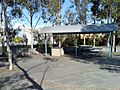
Barbecues available for use at the park on Whitehorse road, on the Outer Circle Trail
-
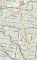
Map of the main trail from Fairfield Station to Gardiners Creek.


