Oztoticpac Lands Map of Texcoco facts for kids
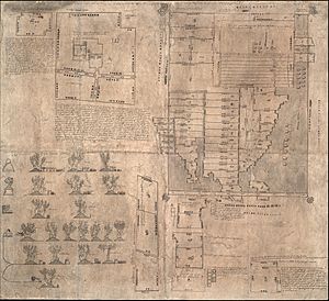
The Oztoticpac Lands Map of Texcoco is a very old and special map from the Aztec times. It was made around 1540 in a place called Texcoco. This map is like an ancient book or document, called a codex, and it's drawn on native paper. Today, you can see it at the Library of Congress in the United States.
This map is unique because it uses both pictures and written words in the Nahuatl language. It tells a story about land ownership. It shows lands that a Texcocan lord named Ixtlilxochitl I might have given to Don Carlos Ometochtzin. Don Carlos was a son of Nezahualpilli, another important leader. The map also shows arguments and legal issues about who owned these lands after Don Carlos faced problems with the authorities. It was likely created to help reclaim land that Don Carlos used to own.
Contents
What is the Oztoticpac Lands Map?
The Oztoticpac Lands Map is a large document, about 76 by 84 centimeters (or about 30 by 33 inches). It's a key part of the Library of Congress's collection. The map shows a palace that belonged to Don Carlos in an area called Oztoticpac. It also shows 75 different pieces of land.
Who Lived on the Land?
The map clearly shows the Nahua families who farmed these lands. It also shows how big each plot of land was. Many of these properties were rented out. The map uses special symbols to show how much rent was paid. The names of the land pieces are also shown with unique picture symbols, called toponymic glyphs. This map is connected to another old document called the Humboldt Fragment VI, which is in a library in Berlin.
Amazing Fruit Trees on the Map
One of the most interesting things about the Oztoticpac Lands Map is its pictures of fruit trees. It shows both European trees and local trees. Many of these trees were grafted. Grafting is a special way to join parts of two plants so they grow as one. This helps make plants healthier and produce more fruit.
European Fruits in the Americas
The map shows trees like pears, quince, apples, pomegranates, peaches, and grapevines. These European fruit trees came to the Americas as part of the Columbian Exchange. This was a big exchange of plants, animals, and ideas between the Old World (Europe, Asia, Africa) and the New World (the Americas). It's amazing that these new trees were not only brought over but also integrated into local farming practices. The fact that they were grafted shows how advanced the farming techniques were at the time.
Understanding the Map's Measurements
For many years, experts have tried to figure out the exact size of the land plots shown on the map. It's been tricky because the map uses Aztec units of measurement. It's hard to translate these old units into modern measurements.
How Scholars Study the Map
In 1991, a scholar named H.R. Harvey suggested that the map actually used two different units of measurement. He used his knowledge of Aztec math to make calculations. Other experts continue to study the map's writing and symbols. They want to understand all the details it holds.
The Map's Importance Today
The Oztoticpac Lands Map is very important. It has a lot of information packed into a relatively small space. Because of all the tiny details, scholars have often needed to make parts of the map bigger to study them. Now, thanks to digital technology, you can explore enlarged sections of the map easily on the Library of Congress website. The Library of Congress sees this map as one of its most valuable treasures. In 2018, they even hosted an online event about it, which you can still find and learn from.
 | Roy Wilkins |
 | John Lewis |
 | Linda Carol Brown |


