Pablo, Montana facts for kids
Quick facts for kids
Pablo, Montana
|
|
|---|---|

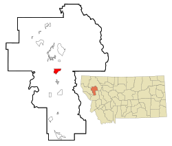
Location of Pablo, Montana
|
|
| Country | United States |
| State | Montana |
| County | Lake |
| Area | |
| • Total | 4.85 sq mi (12.56 km2) |
| • Land | 4.85 sq mi (12.56 km2) |
| • Water | 0.00 sq mi (0.00 km2) |
| Elevation | 3,091 ft (942 m) |
| Population
(2020)
|
|
| • Total | 2,138 |
| • Density | 441.01/sq mi (170.28/km2) |
| Time zone | UTC-7 (Mountain (MST)) |
| • Summer (DST) | UTC-6 (MDT) |
| ZIP code |
59855
|
| Area code(s) | 406 |
| FIPS code | 30-56350 |
| GNIS feature ID | 0775026 |
Pablo is a small community in Lake County, Montana, USA. It's called a 'census-designated place' because it's a special area defined for counting people. In 2020, about 2,138 people lived there.
Pablo is home to Salish Kootenai College. It's also where the government for the Flathead Indian Reservation is located.
Contents
History of Pablo, Montana
Pablo started in 1917. This was when the Northern Pacific Railway finished building a train line. The line connected Dixon and Polson.
The town is named after Michel Pablo. He was famous for his efforts to save the American bison. He worked hard to keep these animals from disappearing forever.
People's Center Fire Incident
On September 6, 2020, a fire happened at the People's Center. This center was an important place for learning and a museum. It focused on the history and culture of the Flathead people.
Sadly, the fire damaged some parts of the building. The storage room, offices, and a commercial room were lost. However, the main entrance, education room, and museum area were saved. Many items from the collection are now safe. They have been moved to the Dr. Joe McDonald Health and Activity Center. This center is on the campus of Salish Kootenai College.
Geography and Climate
Pablo is located near the Pablo National Wildlife Refuge. This is a special area for protecting wildlife.
The community covers about 12.6 square kilometers (4.85 square miles) of land. Only a very small part, about 0.04%, is water.
Pablo's Climate Type
Pablo experiences a climate with big temperature changes throughout the year. Summers are usually warm to hot, and sometimes humid. Winters are cold, and can be very chilly.
According to the Köppen Climate Classification system, Pablo has a "humid continental climate." This type of climate is known for its distinct seasons.
Population and People
| Historical population | |||
|---|---|---|---|
| Census | Pop. | %± | |
| 2000 | 1,814 | — | |
| 2010 | 2,254 | 24.3% | |
| 2020 | 2,138 | −5.1% | |
| U.S. Decennial Census | |||
In 2000, there were 1,814 people living in Pablo. These people lived in 622 households. About 475 of these were families.
The population was spread out by age:
- 38.5% were under 18 years old.
- 9.9% were between 18 and 24 years old.
- 27.9% were between 25 and 44 years old.
- 17.0% were between 45 and 64 years old.
- 6.7% were 65 years or older.
The average age in Pablo was 26 years old.
Education in Pablo
Pablo is home to Salish Kootenai College. This college is controlled by the local Native American tribes. It was started in 1977. In 1981, it became independent and grew its programs. The college offers two-year and four-year degrees. It also has three smaller campuses in eastern Washington state.
The community has several schools for younger students:
- Two elementary schools
- One middle school
- Two Eagle River School, which is the high school
In the 2021-2022 school year, Two Eagle River School had 62 students. These students were in grades 8 through 12. Two Eagle River School is a Class C high school. This classification helps decide how athletic competitions are organized. Their sports teams are known as the Eagles.
Local Media and News
The Char-Koosta News is the newspaper for the Flathead Indian Reservation. The Valley Journal provides local news for several nearby towns. These include Arlee, Charlo, Pablo, Polson, Ronan, and St. Ignatius.
Pablo also has a local radio station. It is called KQRK and broadcasts on the FM dial. This station plays country music.
Transportation and Services
U.S. Route 93 is a major highway that goes through Pablo. It passes just east of the town center. This highway connects Pablo to other towns:
- North to Polson, which is about 8 miles away. Polson is the county seat.
- South to Ronan, which is about 5 miles away.
The Ronan Airport is a public airport located north of Pablo.
For healthcare, St. Luke Community Healthcare provides services. They have both a hospital and a clinic in nearby Ronan. In 2023, the first part of the Ronan Health Center was finished.
See also
 In Spanish: Pablo (Montana) para niños
 | Bayard Rustin |
 | Jeannette Carter |
 | Jeremiah A. Brown |


