Paccharaju facts for kids
Quick facts for kids Paccharaju |
|
|---|---|
| Rocotuyo - Rayococha | |

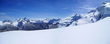
Paccharaju (center) as seen from the south
|
|
| Highest point | |
| Elevation | 5,749 m (18,862 ft) |
| Geography | |
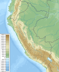
| Location | Ancash, Peru |
| Parent range | Andes, Cordillera Blanca |
Paccharaju is a tall mountain in the Cordillera Blanca mountain range, which is part of the larger Andes mountains in Peru. It stands at about 5,749 meters (18,862 feet) high. The name Paccharaju might come from the local Ancash Quechua language, meaning "waterfall snow peak."
Some maps show Paccharaju as having two main peaks. One is called Rocotuyo, which is the higher peak at 5,749 meters. The other peak is Rayococha (sometimes called Bayoraju), which is a bit lower at 5,460 meters (17,913 feet).
This impressive mountain is located in the Ancash Region of Peru. It sits between the Asunción Province and the Carhuaz Province. Paccharaju is found southwest of another mountain called Tarush Kancha. It is also an important part of the famous Huascarán National Park.
Contents
About the Mountain
Paccharaju is a snow-capped mountain, meaning its top is covered in snow and ice all year round. It is a significant landmark in the Cordillera Blanca, a range known for its many high peaks and glaciers. The mountain's rugged beauty attracts climbers and adventurers from around the world.
Nearby Features
South of Paccharaju, there is a lake also named Rocotuyo (sometimes called Paccharuri). This lake is located at coordinates 9°16′53″S 77°27′12″W. Lakes like Rocotuyo are often formed by melting glaciers from the surrounding mountains.
Huascarán National Park
Paccharaju is located inside Huascarán National Park. This park is a very special place in Peru. It was created to protect the unique plants, animals, and beautiful landscapes of the Cordillera Blanca. The park is also a UNESCO World Heritage Site, which means it's recognized globally for its importance.
Why the Park is Important
Huascarán National Park is home to many different kinds of wildlife, including rare animals like the Andean condor and the vicuña. It also protects unique plants that grow in the high Andes. The park's glaciers and snow-capped peaks, like Paccharaju, are vital sources of water for the region.
Climbing Paccharaju
Climbing Paccharaju is a challenging adventure, usually attempted by experienced mountaineers. The mountain's steep slopes and icy conditions require special equipment and skills. Climbers often need to be prepared for cold weather and high altitudes.
Routes and Challenges
The exact routes to the summit of Paccharaju can vary, but they generally involve navigating glaciers and rocky sections. Climbers often spend several days on the mountain, slowly getting used to the high altitude. This helps them avoid altitude sickness, which can be a serious problem.
See also
 In Spanish: Paccharaju para niños
 | Kyle Baker |
 | Joseph Yoakum |
 | Laura Wheeler Waring |
 | Henry Ossawa Tanner |


