Pacha Qullu facts for kids
Quick facts for kids Pacha Qullu |
|
|---|---|
| Kimsa Misa | |

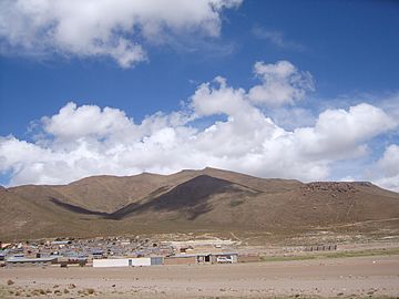
The village of Huachacalla with the eastern slopes of Pacha Qullu in the background
|
|
| Highest point | |
| Elevation | 4,702 m (15,427 ft) |
| Geography | |
| Parent range | Andes |
Pacha Qullu is a tall mountain in the Andes mountain range in Bolivia. It stands about 4,702 meters (15,426 feet) high.
The name Pacha Qullu comes from the Aymara language. Pacha means "world" or "time," and qullu means "mountain." So, it can mean "world mountain" or "time mountain." It is also known as Kimsa Misa, where kimsa means "three" and misa means "offering."
Where is Pacha Qullu?
This mountain is located in the Oruro Department of Bolivia. You can find it in the Litoral Province, near the town of Huachacalla. It sits west of Huachacalla and northwest of another mountain called Inka Qhamachu. There's even a flat area nearby called Kimsa Misa Pampa, named after the mountain.
A Very Old Volcano
Pacha Qullu is actually a volcano, but it hasn't erupted in a very long time. Scientists believe it is about 8.3 million years old! This makes it a very ancient volcano from the Pliocene age.
When it was first formed, Pacha Qullu was much taller. It used to be about 89 meters (292 feet) higher than it is today. Over millions of years, wind, rain, and other natural forces have worn it down.
The sides of the volcano are made up of hardened lava flows and pieces of rock that exploded from the volcano (called pyroclastic material). These slopes are quite steep. Over time, water has carved deep channels, called gullies, into the mountain's sides. At the bottom of these gullies, flat areas of rock and soil have formed.
A long time ago, a large part of the volcano's side collapsed. This created a huge break in the mountain, about 2.4 kilometers (1.5 miles) wide and 4.7 kilometers (2.9 miles) long.
Climate and Plants
The area around Pacha Qullu has a cool and dry climate. In the nearby city of Oruro, temperatures usually range from 4 to 12 degrees Celsius (39 to 54 degrees Fahrenheit). It doesn't rain much, with only about 400 to 100 millimeters (16 to 4 inches) of rainfall each year. It's also a very windy place!
Because of this dry and windy climate, the plants that grow here are special. They are called xerophytic plants, which means they are adapted to live in very dry conditions. You might see tough shrubs and tussock grass growing on the mountain and in the surrounding plains.
See also
 In Spanish: Pacha Kkollu Quimsa Misa para niños
 | Bessie Coleman |
 | Spann Watson |
 | Jill E. Brown |
 | Sherman W. White |


