Pachalum facts for kids
Quick facts for kids
Pachalum
|
|
|---|---|
|
Municipality
|
|
| Country | |
| Department | |
| Municipality | Pachalúm |
| Government | |
| • Type | Municipal |
| Area | |
| • Municipality | 100 km2 (40 sq mi) |
| Population
(Census 2002)
|
|
| • Municipality | 7,037 |
| • Urban | 2,042 |
| • Ethnicities | K'iche' Ladino |
| • Religions | Roman Catholicism Evangelicalism Maya |
| Climate | Aw |
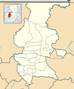
Pachalúm is a town in Guatemala. It's located in the El Quiché area. Before 1986, Pachalúm was a village within the town of Joyabaj. But in 1986, it became its own separate town.
Contents
Discovering Pachalúm's Past
The name "Pachalúm" comes from a game called the Pachecas' game. Men used to play this game under a "Chalum" tree in the early 1900s.
Pachalúm During Spanish Rule
During the time of the Spanish colony, a man named José de Alvarado received a lot of land in the Santa María Xoyavaj region. This led to Spanish families settling in the area.
Pachalúm was first mentioned in 1817. It was known as a place where sugar was produced. Spanish families came to Pachalúm from places like San Martín Jilotepeque, Santa Cruz El Chol, and other parts of what is now the Baja Verapaz Department.
Pachalúm After Guatemala's Independence
After Guatemala gained independence from Spain, there was a big change in government around 1871. The families who helped with this change asked the mayor of Joyabaj if their settlement could become a village. This request was approved on August 9, 1872.
How Pachalúm is Organized
The town of Pachalúm covers an area of 100 square kilometers (about 38.6 square miles). Besides the main town, it includes eight villages, thirteen smaller settlements, and five farm fields.
| Division | Name | Settlements |
|---|---|---|
| Villages | Las Moritas | El Naranjito |
| Los Altos | Piedras Blancas | |
| El Cimarrón | Caseríos Toro Seco, Las Minas y San José El Jute | |
| El Ciprés | Ciprés Segundo Centro | |
| Llano Grande | San Vicente | |
| Agua Zarca | Tamarindo y Trapichitos | |
| Volcancillos | Veguitas de Mercedes, Guachipilín, El Anono y Tablones | |
| Las Vegas | N/A | |
| Farm fields | La Laguna Seca | |
| San Isidro | ||
| El Maguey | ||
| San Miguel | ||
| Incienso | ||
Pachalúm's Geography
Pachalúm is located in the Sierra de Chuacús mountain range. It sits at the base of Tuncaj Hill, where several small streams begin. The town is also near the Motagua river basin. Rivers like Las Vegas and Tumbadero, which flow into the Motagua, keep the land in Pachalúm moist.
 |
Joyabaj, El Quiché Department municipality | Baja Verapaz Department | Baja Verapaz Department |  |
| Joyabaj, El Quiché Department municipality | Baja Verapaz Department | |||
| Chimaltenango Department | Guatemala Department |
Pachalúm's Climate
Pachalúm has a tropical savanna climate. This type of climate means it's generally warm all year with a wet season and a dry season.
| Climate data for Pachalúm | |||||||||||||
|---|---|---|---|---|---|---|---|---|---|---|---|---|---|
| Month | Jan | Feb | Mar | Apr | May | Jun | Jul | Aug | Sep | Oct | Nov | Dec | Year |
| Mean daily maximum °C (°F) | 26.5 (79.7) |
27.3 (81.1) |
28.8 (83.8) |
28.9 (84.0) |
28.7 (83.7) |
27.4 (81.3) |
27.3 (81.1) |
27.4 (81.3) |
26.8 (80.2) |
26.5 (79.7) |
26.4 (79.5) |
26.3 (79.3) |
27.4 (81.2) |
| Daily mean °C (°F) | 20.0 (68.0) |
20.1 (68.2) |
21.8 (71.2) |
22.4 (72.3) |
22.7 (72.9) |
22.3 (72.1) |
22.1 (71.8) |
21.9 (71.4) |
21.6 (70.9) |
21.2 (70.2) |
20.4 (68.7) |
19.7 (67.5) |
21.3 (70.4) |
| Mean daily minimum °C (°F) | 13.5 (56.3) |
13.6 (56.5) |
14.9 (58.8) |
16.0 (60.8) |
16.7 (62.1) |
17.3 (63.1) |
17.0 (62.6) |
16.5 (61.7) |
16.4 (61.5) |
15.9 (60.6) |
14.5 (58.1) |
13.2 (55.8) |
15.5 (59.8) |
| Average precipitation mm (inches) | 3 (0.1) |
7 (0.3) |
12 (0.5) |
35 (1.4) |
111 (4.4) |
247 (9.7) |
168 (6.6) |
127 (5.0) |
208 (8.2) |
121 (4.8) |
28 (1.1) |
5 (0.2) |
1,072 (42.3) |
| Source: Climate-Data.org | |||||||||||||
See also
 In Spanish: Pachalum para niños
 | Frances Mary Albrier |
 | Whitney Young |
 | Muhammad Ali |


