Paget Peak facts for kids
Quick facts for kids Paget Peak |
|
|---|---|

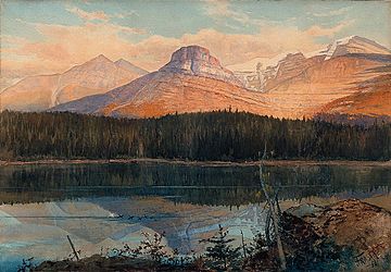
Summit Lake near Lenchoile, Bow River, Canadian Pacific Railway, by John Arthur Fraser.
Possibly Paget Peak and Sherbrooke Lake in British Columbia |
|
| Highest point | |
| Elevation | 2,560 m (8,400 ft) |
| Geography | |
| Location | Yoho National Park, British Columbia, Canada |
| Climbing | |
| First ascent | Dean Pager |
Paget Peak is a mountain located in Yoho National Park, British Columbia, Canada. It's a popular spot for hikers and can be reached by a well-known trail.
Contents
Discover Paget Peak
Paget Peak stands tall at 2,560 meters (about 8,400 feet) high. It is found within Yoho National Park in British Columbia. This mountain is at the southern end of the Mount Daly mountain range. It sits right next to Mount Bosworth.
Where is Paget Peak Located?
Paget Peak is just south of the Continental Divide of the Americas. This divide separates rivers that flow to the Pacific Ocean from those flowing to the Atlantic. The peak is also only 2 kilometers (about 1.2 miles) north of Wapta Lake. From the top, you can enjoy amazing views of both Wapta Lake and Sherbrooke Lake.
Who is Paget Peak Named After?
The mountain is named after Dean Paget. He was the first person known to climb to its summit. Dean Paget was also one of the people who helped start the Alpine Club of Canada (ACC). He reached the top with a group of other ACC members. Another important climb was made by the surveyor James J. McArthur in 1886.
Hiking to Paget Peak
You can start your adventure to Paget Peak from a parking lot. This lot is on the north side of the Trans-Canada Highway. It's right across from Wapta Lake, just west of the border with Alberta.
The Paget Peak Trail
To reach the mountain, you first follow the Sherbrooke Lake trail for 1.8 kilometers (about 1.1 miles). After that, you'll switch to the Paget Lookout trail. This trail leads you to an old fire lookout building. It's on the southern side of the mountain. This lookout was one of the first ever built in Yoho National Park.
History of the Fire Lookout
The lookout was built after several serious forest fires. These fires happened in the late 1930s and early 1940s. Park rangers used the lookout to spot fires until the late 1970s. Today, it's no longer used, but it's a cool historical spot on the trail.
Trail Details for Hikers
The entire round trip hike is 11.3 kilometers (about 7 miles) long. You will gain about 985 meters (3,232 feet) in elevation. This hike is considered moderately difficult. The best time to go is from June to September. If you want to reach the very top of Paget Peak, you can scramble (climb using your hands and feet) from the lookout point.
 | Charles R. Drew |
 | Benjamin Banneker |
 | Jane C. Wright |
 | Roger Arliner Young |


