Pamet River facts for kids
Quick facts for kids Pamet River |
|
|---|---|

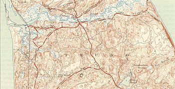
Pamet River map
|
|
| Country | United States |
| State | Massachusetts |
| Region | Barnstable County |
| City | Truro |
| Physical characteristics | |
| River mouth | Cape Cod Bay |
| Length | 4 mi (6.4 km) |
The Pamet River is a short river, about 4.2-mile-long (6.8 km), located in Truro, Massachusetts. This town is found on the famous hook-shaped landmass called Cape Cod. The river gets its name from the Paomet tribe, who were Native Americans living in the area.
This unique river flows almost all the way across Cape Cod. It starts near the eastern beaches and flows west. Finally, it empties its waters into Cape Cod Bay. Much of the Pamet River is a salt marsh, which is a coastal wetland area. It is also a few miles south of a smaller river called the Little Pamet River.
Contents
How the Pamet River Formed
The Pamet River has a very interesting history, going back thousands of years. The upper part of the Pamet River is a freshwater marsh. This means it's a wetland with fresh water, not salty ocean water. This marsh sits in a wide valley.
The River's Ancient Past
About 12,000 to 13,000 years ago, this valley was a huge channel. It was formed by melting ice from a glacier. This channel carried water away from the glacier, flowing west, then north, and finally east into the Atlantic Ocean. Back then, the ocean's surface was much lower, about 300 to 400 feet (91 to 122 m) lower than it is today! There was no Cape Cod Bay yet. Places like Stellwagen Bank and the Grand Banks were actually dry land, like hills above the ocean.
Changes Over Time
Over many thousands of years, the Atlantic Ocean's level slowly rose. This rise continues even now. As the ocean rose, it almost covered the outer part of Cape Cod, including the Pamet River valley. The Pamet River, which was once about 30 miles (48 km) long, is now only about four miles long because of this rising sea.
Creating the Freshwater Marsh
In the mid-1800s, people wanted to use the land near the river for farming. To do this, they built a special wall called a dike across the valley. This dike stopped the salty ocean tides from flowing into the upper part of the river. Today, Route 6A (Truro Center Road) passes over this dike.
A special one-way door, called a clapper valve, was also put in place. This valve allowed fresh water to flow out of the marsh when the tide was low, but it stopped salt water from coming in when the tide was high. Because of this, the upper Pamet River became a slow, winding stream with low, flat banks.
Beneath the entire valley, both the fresh and salt parts, there is a thick layer of peat. Peat is a dark, spongy material made from old, decayed plants from the original salt marshes.
Plants and Animals
All the plants growing in the upper, freshwater part of the Pamet River came from seeds. These seeds were mostly carried there by birds and other animals. These plants are indigenous, meaning they are native to the area. Almost none of them can survive in salty seawater.
MassWildlife, a state agency, has also added fish to the river. They have stocked the river with trout, making it a place where these fish can live.
 | James Van Der Zee |
 | Alma Thomas |
 | Ellis Wilson |
 | Margaret Taylor-Burroughs |

