Papallacta facts for kids

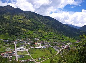
Papallacta is a small village located high in the Andes mountains of Ecuador. It sits at an altitude of about 3,300 meters (which is over 10,800 feet) above sea level. This makes it a very cool and often misty place! Papallacta is found in Napo Province and is well-known for its natural hot springs. As of 2022, about 635 people live in this peaceful mountain community.
Contents
Welcome to Papallacta
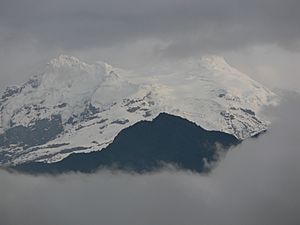
Papallacta is a popular spot for both locals and tourists. Many people visit to relax in the warm, mineral-rich waters of its hot springs. The village is surrounded by stunning mountain scenery, including views of the Antisana volcano.
The Famous Hot Springs
The hot springs in Papallacta are natural pools of water heated deep inside the Earth. This happens because the area is close to volcanoes, which warm the rocks underground. The water then flows up to the surface, creating these wonderful warm baths. People believe the minerals in the water can be good for your health and help you relax. There are several different pools, some very hot and some cooler, so you can find the perfect temperature.
Weather in Papallacta
The climate in Papallacta is cool and often rainy because it's so high up in the mountains. Even though it's near the equator, the altitude means it's never very hot. The temperatures usually stay between 5°C (41°F) and 15°C (59°F) throughout the year. It rains quite a bit, especially from May to July. This rain helps keep the surrounding nature green and lush.
| Climate data for Papallacta, elevation 3,160 m (10,370 ft), (1971–2000) | |||||||||||||
|---|---|---|---|---|---|---|---|---|---|---|---|---|---|
| Month | Jan | Feb | Mar | Apr | May | Jun | Jul | Aug | Sep | Oct | Nov | Dec | Year |
| Mean daily maximum °C (°F) | 14.4 (57.9) |
14.4 (57.9) |
13.9 (57.0) |
14.2 (57.6) |
13.8 (56.8) |
12.6 (54.7) |
12.0 (53.6) |
12.3 (54.1) |
13.0 (55.4) |
14.6 (58.3) |
15.3 (59.5) |
14.6 (58.3) |
13.8 (56.8) |
| Mean daily minimum °C (°F) | 5.2 (41.4) |
5.4 (41.7) |
5.8 (42.4) |
6.0 (42.8) |
6.0 (42.8) |
5.3 (41.5) |
5.2 (41.4) |
5.0 (41.0) |
5.1 (41.2) |
5.2 (41.4) |
5.5 (41.9) |
5.2 (41.4) |
5.4 (41.7) |
| Average precipitation mm (inches) | 121.0 (4.76) |
85.0 (3.35) |
107.0 (4.21) |
114.0 (4.49) |
159.0 (6.26) |
163.0 (6.42) |
179.0 (7.05) |
145.0 (5.71) |
123.0 (4.84) |
97.0 (3.82) |
83.0 (3.27) |
71.0 (2.80) |
1,447 (56.98) |
| Average relative humidity (%) | 88 | 91 | 90 | 90 | 91 | 90 | 89 | 88 | 88 | 88 | 88 | 89 | 89 |
| Source: FAO | |||||||||||||
Nature and Wildlife Around Papallacta
Beyond the hot springs, Papallacta is a gateway to amazing natural areas. It's located near the edge of the páramo, which is a unique high-altitude grassland ecosystem. You can also find cloud forests nearby. These areas are home to many different plants and animals. If you're lucky, you might spot special birds like hummingbirds or even the rare Andean bear (also known as the spectacled bear). Hiking trails offer chances to explore the beautiful landscapes and enjoy the fresh mountain air.
See also
 In Spanish: Papallacta para niños
 | Valerie Thomas |
 | Frederick McKinley Jones |
 | George Edward Alcorn Jr. |
 | Thomas Mensah |


