Paratoo, South Australia facts for kids
Quick facts for kids ParatooSouth Australia |
|||||||||||||||
|---|---|---|---|---|---|---|---|---|---|---|---|---|---|---|---|

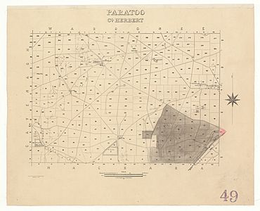
Hundred of Paratoo (drawing dated 1940) whose boundary coincides with the locality of Paratoo as of 2013.
|
|||||||||||||||
| Established | 31 August 2000 | ||||||||||||||
| Postcode(s) | 5422 | ||||||||||||||
| Elevation | 303 m (994 ft)(railway station) | ||||||||||||||
| Area | 390 km2 (150.6 sq mi) | ||||||||||||||
| Time zone | ACST (UTC+9:30) | ||||||||||||||
| • Summer (DST) | ACDT (UTC+10:30) | ||||||||||||||
| Location |
|
||||||||||||||
| LGA(s) | District Council of Peterborough | ||||||||||||||
| Region | Yorke and Mid North | ||||||||||||||
| County | Herbert | ||||||||||||||
| State electorate(s) | Stuart | ||||||||||||||
| Federal Division(s) | Grey | ||||||||||||||
|
|||||||||||||||
|
|||||||||||||||
| Footnotes | Adjoining localities | ||||||||||||||
Paratoo is a small area in the Australian state of South Australia. It is located about 254 kilometers (158 miles) north-east of Adelaide, the state capital. It is also about 52 kilometers (32 miles) north-east of Peterborough.
Contents
Discovering Paratoo
Paratoo was officially named on August 31, 2000. The name comes from the old Paratoo Railway Station. This name itself came from an Aboriginal word. The exact meaning of this word is not known today.
How Paratoo's Boundaries Changed
The area of Paratoo was first used as a property by Messrs Dare and Mundy around 1858. In 2013, more land was added to the northern side of Paratoo. This was done to make sure its boundaries fit well with a new nearby area called Waroonee. The boundaries of Paratoo are the same as an older land unit called the Hundred of Paratoo.
Places Named Paratoo
Some places that have 'Paratoo' in their name are actually located just east of the main Paratoo area. These places are in the nearby area of Grampus. They include a place called Paratoo, which is an 'unbounded locality' (meaning it's a recognized place but without fixed borders).
There is also the historic Paratoo Homestead. This was part of the original station owned by Dare & Mundy around 1885. The Paratoo Post Office, which opened in 1864, was also located here.
Transport and Land Use
The Barrier Highway and the Crystal Brook-Broken Hill railway line both pass through the south-east part of Paratoo. They run in a north-easterly direction from Peterborough.
The main use of land in Paratoo is for 'primary production'. This means the land is used for farming and raising animals. This usually happens on very large properties in the area.
Government and Representation
Paratoo is part of different government areas. For national elections, it is in the federal division of Grey. For state elections, it is in the electoral district of Stuart. Locally, it is managed by the District Council of Peterborough.
 | Victor J. Glover |
 | Yvonne Cagle |
 | Jeanette Epps |
 | Bernard A. Harris Jr. |


