Parchim Rural District facts for kids
Quick facts for kids
Parchim
|
||
|---|---|---|
|
||
 |
||
| Country | ||
| State | Mecklenburg-Western Pomerania | |
| Disbanded | September 2011 | |
| Capital | Parchim | |
| Area | ||
| • Total | 2,233 km2 (862 sq mi) | |
| Population
(2001)
|
||
| • Total | 107,996 | |
| • Density | 48.364/km2 (125.261/sq mi) | |
| Time zone | UTC+1 (CET) | |
| • Summer (DST) | UTC+2 (CEST) | |
| Vehicle registration | PCH | |
| Website | http://www.kreis-pch.de/ | |
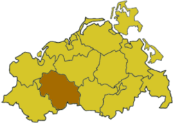
Parchim was a former district in the southwestern part of Mecklenburg-Western Pomerania, Germany. It was a place where many people lived and worked. In September 2011, this district was combined with others to form a new, larger district.
Contents
Exploring Parchim's Landscape
The area of Parchim was mostly used for farming. This means lots of fields and open land. But in the eastern part, you could find several beautiful lakes. The biggest lake was called the Plauer See. It's quite large, covering about 39 square kilometers! The Plauer See was also the start of the famous Müritz lakeland area.
A Look Back at Parchim's History
Before 1994, the area that became the Parchim district was actually split into three smaller districts. These were the districts of Parchim, Sternberg, and Lübz. Later, they all joined together to form the larger Parchim district.
Understanding the Coat of Arms
Towns and Communities in Parchim
The Parchim district was made up of one main town and several groups of smaller towns and villages. These groups are called Ämter in Germany. An Amt is like a local administrative area that helps manage several smaller communities together.
Main Town of Parchim
The biggest town in the district was Parchim itself. It was the main center for the area.
The Ämter and Their Communities
The district had several Ämter, each with its own group of towns and villages. Here are some examples:
- Banzkow: This Amt included communities like Banzkow, Goldenstädt, and Plate.
- Crivitz: Key places here were Crivitz, Barnin, and Bülow.
- Eldenburg Lübz: This Amt had many communities, including Lübz, Granzin, and Marnitz.
- Goldberg-Mildenitz: Here you would find towns like Goldberg and villages such as Dobbertin.
- Ostufer Schweriner See: This Amt was located on the eastern side of the Schweriner See. It included places like Leezen and Pinnow.
- Parchimer Umland: This Amt was around the main town of Parchim. It included communities like Damm and Spornitz.
- Plau am See: This Amt was named after the town of Plau am See. Other communities included Barkhagen and Ganzlin.
- Sternberger Seenlandschaft: This Amt was known for its lakes. It included towns like Sternberg and villages such as Brüel.
 | Precious Adams |
 | Lauren Anderson |
 | Janet Collins |


