Parspatunik facts for kids
Parspatunik (also known as Parspatuniq) was an important historical region in ancient times. It was the 26th district of a large area called Vaspurakan province. Parspatunik was also the biggest region (about 550 square kilometers) in the ancient kingdom of Greater Armenia.
After 72 A.D., Parspatunik became a special area called a principality within Greater Armenia. This principality included two regions: Parspatunik itself and another area called Marand. A noble family known as the Parspatuni (or Patsparuni) family ruled this region.
Contents
A Look Back: The History of Parspatunik
Early Times: Scythians and Urartu
Long, long ago, the main part of Parspatunik (which is now called Karadag) was part of a state ruled by the Scythian people. In the western part of Parspatunik, the ancient region of Sangibutu was located, with its center in Marand.
Later, this area became part of the powerful kingdom of Urartu. After a while, the Scythians took control of these lands again.
Empires and Kingdoms
Eventually, Parspatunik became part of the Median Empire. After the huge empire of Alexander the Great was divided, the eastern part of Parspatunik joined a region called Media Atropatena.
However, a famous Armenian king named Artashes I added eastern Parspatunik to Greater Armenia during a military campaign. Marand was already part of the Armenian kingdom even before King Artashes I's conquests.
The Parspatuni Princes
The noble family of Parspatuni came from the Matianian kings of Sangibutu. When they became princes, the Parspatuni rulers brought the regions of Parspatunik and Marand together under their control. They chose a city in Marand called Bakurarakert (also known as Philadelphia) as their capital.
Later Changes and Divisions
In 591 A.D., Greater Armenia was divided for a second time by the Roman and Sasanids empires. During this division, Parspatunik was not included in Vaspurakan province.
Later, when the Arab caliphate ruled the region, Parspatunik was no longer part of Vaspurakan. Many people in Parspatunik adopted the Islamic faith during the time of the Caliphate.
Where Was Parspatunik?
Location and Borders
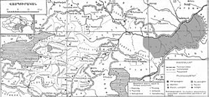
Parspatunik was located between the Araxes River to the north and the Parthian Empire to the south.
There was a wooded mountain range in Parspatunik, also known as the Matiani mountains. In ancient times, these mountains were called the Armenian Mountains (Armenio Orei). They had a special pass called the Armenian Gate (Armenion Pylon or Drunq Hayots).
A Greek writer named Eratosthenes described this gate in the 3rd century B.C. A Muslim historian named Hamballah Ghazvini also mentioned it in the 14th century. In the Middle Ages, the road through the Armenian Gate led to the famous Khudapery Bridge.
The "Wall of Persia"
Because of its location, Parspatunik was right on the border between the Armenian and Parthian kingdoms. This is why the region got its Armenian name, which means "Wall of Persia." It comes from the words "Pars" (Persia) and "pat" (wall). The Matiani mountains in Parspatunik acted like an old border between Armenia and Iran.
A Region of Vaspurakan
From the 1st to the 6th centuries, Parspatunik was the 26th "ghawar" (which means region) and a principality of the Armenian province of Vaspurakan. This was written by Anania Shirakatsi, an Armenian geographer and historian from the 7th century.
Who Lived in Parspatunik?
Different Tribes and Peoples
Most of the people living in Parspatunik were Iranian tribes, including those from Atropatena and Caspian areas.
The Armenian population, who were originally from the Matiene and Alarodian tribes, lived mainly in the towns and wooded mountain areas near fortresses. Some of their descendants still live in modern Iran today.
Armenian Melikdoms
Until the end of the First World War, there were small Armenian "melikdoms" (which were like small, local kingdoms or lordships) in the mountainous, wooded part of Parspatunik (Karadag), near the Araxes River.
Some of these Armenian melikdoms in Karadag (Parspatunik) were started by people who moved there from Karabakh (also known as Artsakh).
Parspatunik Today
The historical region of Parspatunik is now part of the Iranian region called Arasbaran (or Karadag). Many Armenian people left this area during a time of repatriation (returning to their homeland) between 1946 and 1947.
Even so, many old Armenian buildings and monuments are still preserved in the region. The Armenians who remain in Parspatunik (Karadag) mostly live in the mountainous areas, near the borders of the Iranian provinces of Ardabil and East Azerbaijan.
Images for kids
 | Roy Wilkins |
 | John Lewis |
 | Linda Carol Brown |


