
Pasir Ris facts for kids
Quick facts for kids
Pasir Ris
|
|
|---|---|
|
Planning Area and HDB Town
|
|
| Other transcription(s) | |
| • Chinese | 巴西立 / 白沙 |
| • Pinyin | Bāxīlì / Báishā |
| • Malay | Pasir Ris |
| • Jawi | ڤاسير ريس |
| • Tamil | பாசிர் ரிஸ் |
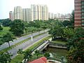
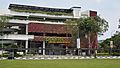
   From top left to right: HDB flats in Pasir Ris, Pasir Ris Elias Community Club, Pasir Ris Park
|
|
.svg)
Pasir Ris
Location in Singapore
|
|
| Country | |
| Region | East Region
|
| CDC |
|
| Town council |
|
| Constituency |
|
| Area | |
| • Total | 15.02 km2 (5.80 sq mi) |
| • Residential | 3.18 km2 (1.23 sq mi) |
| Population
(2018)
|
|
| • Total | 146,920 |
| • Density | 9,782/km2 (25,334/sq mi) |
| Demonym(s) | Official
Colloquial
|
| Postal districts |
17, 18
|
| Dwelling units | 29,207 |
| Projected ultimate | 44,000 |
Pasir Ris (which means "white sand" in Malay) is a vibrant town located in the eastern part of Singapore. It's known as a planning area and a residential town, meaning it's a specially planned area where many people live. Pasir Ris is bordered by other towns like Tampines and Paya Lebar to the south. To its east is Changi, and to the west, it shares a river boundary with Punggol across the Serangoon River. It also has a sea boundary with the North-Eastern Islands across the Straits of Johor.
Pasir Ris is a great place to live with easy access to different parts of Singapore. It has a well-planned public transport system. You can easily get around using bus services at the Pasir Ris Bus Interchange. The MRT train system also connects Pasir Ris through the Pasir Ris MRT Station. This makes it simple for residents to travel for school, work, or fun!
Contents
Exploring Pasir Ris: Fun Places to Visit
Pasir Ris is home to many exciting places. These spots are popular with both residents and visitors.
Parks and Recreation
Pasir Ris is famous for its green spaces and coastal areas.
- Pasir Ris Park is a large park with a beautiful beach. It's perfect for cycling, picnics, and enjoying nature.
- The park also has a mangrove forest. This unique area is home to many plants and animals.
- You can also find the NTUC Pasir Ris Resort here. It's a popular place for families to stay and relax.
Shopping and Community
Pasir Ris offers convenient shopping and community facilities.
- White Sands shopping mall is a popular spot for shopping and dining. It has many stores and restaurants.
- The Pasir Ris Elias Community Club is a place where people can gather. It hosts many activities and events for all ages.
How Pasir Ris is Governed
Like other towns in Singapore, Pasir Ris is managed by different groups. These groups help make sure the town runs smoothly.
Local Leadership
- Pasir Ris is part of the North East CDC. This council helps to improve the lives of residents.
- The Mayor of the North East CDC is Desmond Choo. He works to support the community.
- The town is also managed by the Pasir Ris-Punggol Town Council. They look after the housing estates and common areas.
Representing the People
- Pasir Ris is part of the Pasir Ris-Punggol GRC. This is an area represented by a team of Members of Parliament (MPs).
- The MPs for Pasir Ris-Punggol GRC include Teo Chee Hean and Zainal Sapari. They represent the residents' interests in Parliament.
Pasir Ris in Numbers
Pasir Ris covers an area of about 15 square kilometers. A significant part of this land, about 3.18 square kilometers, is used for homes. In 2018, the town had a population of around 146,920 people. This means many families call Pasir Ris home! The town also has many homes, with about 29,207 dwelling units. It is planned to have even more homes in the future, with a projected ultimate of 44,000 units.
Images for kids
-
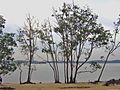
Sungei Api Api in a suburb of Pasir Ris
-
Pasir Ris Beach
-

Pasir Ris beach park
-
Pasir Ris hawker center


