
Patrick Ganly facts for kids
Quick facts for kids
Patrick Ganly
|
|
|---|---|
| Born | 15 October 1809 Dublin, Ireland
|
| Died | 29 October 1899 (90 years) Donnybrook, County Dublin
|
| Resting place | Glasnevin Cemetery, Dublin, Ireland |
| Nationality | Irish |
| Citizenship | Ireland |
| Partner(s) | Eliza Ganly (d.5 January 1894) |
| Scientific career | |
| Fields | Geology, Surveying, Cartography, valuation |
Patrick Ganly (1809—1899) was an Irish scientist who studied the Earth. He worked as a surveyor, which means he measured land. He was also a civil engineer, designing things like roads and bridges. Patrick Ganly was a cartographer, someone who makes maps. He also worked as a valuator, estimating the worth of land and buildings.
Ganly made a very important discovery about how to tell the original 'way up' of rock layers. This method uses something called cross-bedding. His discovery was not fully recognized until many years later.
Contents
Who Was Patrick Ganly?
Patrick Ganly was born in Dublin, Ireland, on October 15, 1809. His father was a bricklayer. In 1827, when he was 18, Ganly started working on a big survey of Ireland. This survey was led by Richard Griffith. It was a first step before the official mapping of Ireland began.
Early Life and Work
Patrick worked with Richard Griffith for many years. From 1830 to 1832, he also worked directly for the Ordnance Survey. This group creates detailed maps of the country.
In 1841, Ganly began studying at Trinity College, Dublin. He earned his Bachelor of Arts (BA) degree in 1849. This degree showed he had a good education.
Later, Griffith became the Commissioner of Valuation. This meant he was in charge of valuing property. Ganly worked under him as a valuator. From 1846 to 1849, during the difficult time of the Great Famine, Ganly helped with relief efforts. He worked for the Board of Works, which Griffith led.
Ganly returned to valuation work in 1853. He was married to Mary Elizabeth, also known as Eliza. He stopped working as a valuator in 1860. Some people think he might have worked in the United States in the early 1850s. After 1860, he may have worked as a civil engineer in Ireland.
Discovering Rock Secrets
In the early 1830s, Ganly drew pictures of how river sediment (like sand or mud) settled. He noticed patterns in the cross-sections of these deposits. These patterns were made by ripples in the riverbed.
In 1838, he made more drawings at Coosnagloor on the Dingle Peninsula. He saw similar patterns, called cross-bedding, in sedimentary rocks along the shore. As he moved south, the rocks seemed to get younger. But at the very end, the layers looked upside down.
He correctly understood that this was due to synclinal folding. This is when rock layers bend into a U-shape. He had found a way to tell which way the rock layers were originally formed. This was a very important discovery for geology!
What is Cross-Bedding?
Imagine a river flowing. It carries sand and tiny bits of rock. When the river slows down, these bits settle on the bottom. They often form small ripples or dunes. As more sediment is added, these ripples get buried.
If you cut through these layers, you'd see diagonal lines. These lines are called cross-beds. They show the direction the water or wind was moving when the sediment was laid down. By looking at these patterns, geologists can tell if a rock layer is still in its original position or if it has been flipped upside down by Earth's movements.
His Important Discoveries
In May 1856, a paper was read for Ganly at the Royal Geological Society of Ireland. It was about fossils found in limestone. On June 11 of that year, he gave his own paper to the Society. He explained his discovery about cross-bedding from 18 years earlier. However, his ideas were not well-received at the time. Still, his paper was published in the Society's journal the next year.
Before Ganly's presentation, another scientist was praised for a discovery about rocks in Killarney. But Ganly had actually identified these rocks 20 years earlier! He had surveyed all 32 counties of Ireland very carefully. He even corrected mistakes on maps, like wrongly classifying some southern slates.
Ganly gave his last paper to the Society in 1861. It was called "On the past intensity of Sunlight, as indicated by Geological Phenomena."
A Hidden Genius
For a long time, people didn't fully know how much Ganly helped geology and map-making in Ireland. His work also helped with Irish genealogy, which is the study of family histories.
In the 1940s, many letters from Ganly to Griffith were found. These letters, written over more than ten years, showed Ganly's detailed fieldwork. Griffith was praised for his excellent maps and even received a special award called the Wollaston Medal. He also became a Baronet. But the maps were much more accurate because of Ganly's hard work and skill in the field. Griffith did not give Ganly credit for this. Also, Griffith's own geology papers used a lot of Ganly's ideas, but he didn't mention Ganly.
Patrick Ganly died on October 29, 1899, at the age of 90. He was buried in Glasnevin Cemetery in Dublin.
Legacy
During his lifetime, other geologists did not fully recognize Ganly's work. But his methods, which are now standard practice, were discovered again in the 1910s in the USA. In the mid-to-late 1900s, researchers finally started to give him the credit he deserved. They recognized his important place in the history of geology and map-making. He has been called "Ireland's greatest, but least well-known, geologist."
Images for kids
-
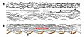
Ganly's sketch of cross-stratification at Carndonagh, County Donegal, Ireland. The bottom shows the direction of river flow (enhanced in red) with the deposited sediment (enhanced in orange) on one side the ripples (c to d). The top shows a cross-section through the riverbed sediment.
-
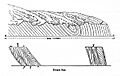
Ganly's sketch of rocks on the shoreline at Coosnagloor, near Mount Eagle on the Dingle peninsula, County Kerry, Ireland. The top part of the sketch shows a tightly folded syncline: north to south the rocks get younger, then the bedding is inverted past the syncline trough. The bottom part details the cross-stratification which helped to indicate the original 'way up' of the rock.


See also
