Pavas facts for kids
Quick facts for kids
Pavas
|
|
|---|---|
|
District
|
|

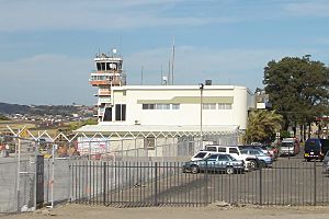
Control tower and main terminal building, Tobias Bolaños International Airport, Pavas, San José, Costa Rica
|
|
| Country | |
| Province | San José |
| Canton | San José |
| Area | |
| • Total | 9.39 km2 (3.63 sq mi) |
| Elevation | 1,044 m (3,425 ft) |
| Population
(2011)
|
|
| • Total | 71,384 |
| • Density | 7,602/km2 (19,689/sq mi) |
| Time zone | UTC−06:00 |
| Postal code |
10109
|
Pavas is a district in Costa Rica. It is part of the San José canton. This canton is located in the San José province. Pavas is well-known for being home to the Tobías Bolaños International Airport. This airport serves as San José's main domestic airport.
Contents
What is Pavas Like?
Pavas covers an area of about 9.39 square kilometers. This makes it the largest district in its canton. The district is located at an elevation of 1044 meters above sea level.
Pavas is surrounded by other areas. To the south, it borders Escazú Canton. To the north and east, it is next to the Uruca and Mata Redonda districts.
How Many People Live in Pavas?
A census is a count of how many people live in an area. The last census in Costa Rica was in 2011. According to this census, Pavas had a population of 71,384 people.
Here is how the population of Pavas has changed over the years:
| Historical population | |||
|---|---|---|---|
| Census | Pop. | %± | |
| 1883 | 732 | — | |
| 1892 | 954 | 30.3% | |
| 1927 | 1,499 | 57.1% | |
| 1950 | 2,127 | 41.9% | |
| 1963 | 5,530 | 160.0% | |
| 1973 | 18,068 | 226.7% | |
| 1984 | 31,690 | 75.4% | |
| 2000 | 76,177 | 140.4% | |
| 2011 | 71,384 | −6.3% | |
|
Instituto Nacional de Estadística y Censos |
|||
Neighborhoods in Pavas
Pavas District includes many different neighborhoods. These are often called "barrios." Some of these neighborhoods are:
- Aeropuerto
- Alfa
- Bribri
- Favorita Norte
- Favorita Sur
- Geroma
- Gerona
- Hispana
- Libertad
- Lomas del Río
- Llanos del Sol
- María Reina
- Metrópolis
- Pavas Centro
- Residencia del Oeste
- Rincón Grande
- Rohrmoser
- Rotonda
- San Pedro
- Santa Bárbara
- Santa Catalina
- Tajo
- Triángulo
- Villa Esperanza
- Zona Industrial
Schools in Pavas
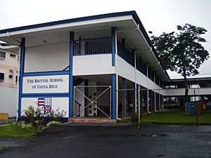
Pavas is home to some international schools. These schools offer education based on different countries' systems.
- British School of Costa Rica
- Colegio Humboldt (also known as Humboldt-Schule), which is a German school.
Getting Around Pavas
There are different ways to travel in and out of Pavas.
Roads
Several important road routes pass through the district:
Trains
The Interurbano Line also runs through Pavas. This train line is operated by Incofer.
See also
 In Spanish: Pavas (San José) para niños
 | Roy Wilkins |
 | John Lewis |
 | Linda Carol Brown |


