Pedro Teixeira Albernaz facts for kids
Pedro Teixeira Albernaz was a famous Portuguese mapmaker born in 1595 in Lisbon, Kingdom of Portugal. He came from a family of mapmakers, including his father Luís Teixeira and his brother João Teixeira Albernaz I, with whom he often worked.
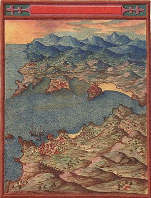
Around 1610, Pedro moved to Spain. He became the official mapmaker for King Philip III of Spain (who ruled from 1598 to 1621) and later for King Philip IV (who ruled from 1621 to 1665). From 1622 to 1630, Pedro focused on mapping the coasts of the Iberian Peninsula (which includes Spain and Portugal). During this time, he changed his focus from making maps for sailors (nautical charts) to creating detailed land maps (topographical survey charts). Pedro and his brother were also asked to create a map of the Straits of Magellan and St. Vincent. Pedro Teixeira Albernaz passed away in 1662 in Madrid.
Important Maps and Works
Pedro Teixeira created many important maps during his life. His works are still studied today because of how detailed and accurate they were for his time.
Mapping Spain's Coasts
One of his most famous works is from 1634, titled La descripción de España y de las costas y puertos de sus reinos. This means Description of Spain and of the Coasts and Ports of Her Kingdoms. This large map is kept safe in Vienna.
The map is made up of twenty separate large sheets of paper, called folios. The pictures and details for the map were carved onto metal plates by an artist named Salomon Savery in Amsterdam. These plates were then used to print the maps in Antwerp in 1656.
This amazing map is very big, about six feet tall and over nine feet wide! It shows what cities looked like when they were ruled by the Habsburg family. The map and the notes around its edges show Spain when it was very powerful. It also gives a very exact picture of how cities were laid out back then.
Maps of Madrid
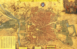
Pedro Teixeira also created detailed maps of the city of Madrid. These maps are very helpful for understanding what the city looked like in the 17th century. Some of his notable works include:
- Carta dos Estreitos de S. Vicente e Magalhães (1621) - A map of the Straits of St. Vincent and Magellan.
- La descripción de España y de las costas y puertos de sus reinos (1634) - The large map of Spain's coasts.
- Topografía de Madrid (1656) - A detailed map showing the layout of Madrid.
- Corral de la Cruz. Madrid (1656) - A map showing a specific theater in Madrid.
- El convento de la Trinidad Calzada de Madrid en el plano de Teixeira (1656) - A map showing a convent in Madrid.
- Corral del Príncipe. Madrid (1656) - Another map showing a theater in Madrid.
See also
 In Spanish: Pedro Teixeira (cartógrafo) para niños
 | DeHart Hubbard |
 | Wilma Rudolph |
 | Jesse Owens |
 | Jackie Joyner-Kersee |
 | Major Taylor |


