Pelham Range facts for kids
Quick facts for kids Pelham Range |
|
|---|---|
| Highest point | |
| Dimensions | |
| Area | 52 km2 (20 sq mi) |
| Geography | |
| Country | Canada |
| State/Province | British Columbia |
| Parent range | Vancouver Island Ranges |
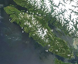
The Pelham Range is a small group of mountains located on the southern part of Vancouver Island in British Columbia, Canada. It's found northeast of a place called Sarita and sits between the Sarita River and Alberni Inlet.
This mountain range covers an area of 52 square kilometers. It's part of a larger group of mountains called the Vancouver Island Ranges. These ranges are themselves a section of the even bigger Insular Mountains.
Contents
Exploring the Pelham Range
The Pelham Range might be small, but it's an interesting part of British Columbia's amazing landscape. It's a great example of the many mountain ranges that make up this beautiful province.
Where is the Pelham Range?
The Pelham Range is on Vancouver Island, which is a large island off the west coast of Canada. To find it on a map, look for the southern part of the island. It's near the water, specifically between the Sarita River and Alberni Inlet. This location means it's surrounded by the natural beauty of the island, including forests and coastal areas.
What is a Mountain Range?
A mountain range is a group of mountains that are connected. They are usually formed by the same geological processes. The Pelham Range is a good example of a "subrange," which means it's a smaller part of a much larger mountain system. In this case, it's a subrange of the Vancouver Island Ranges.
The Vancouver Island Ranges
The Vancouver Island Ranges are the main mountain chain that runs along Vancouver Island. They are known for their rugged peaks and deep valleys. The Pelham Range is just one small piece of this larger mountain puzzle. These ranges are part of the even bigger Insular Mountains, which stretch along the coast of British Columbia.
 | Sharif Bey |
 | Hale Woodruff |
 | Richmond Barthé |
 | Purvis Young |


