Pelsall Junction facts for kids
Pelsall Junction is a special place where two canals meet. It's like a crossroads for boats! Here, the Cannock Extension Canal joins the main line of the Wyrley and Essington Canal. You can find it near a town called Pelsall in the West Midlands, England.
Contents
A Look Back: How Pelsall Junction Began
Canals were very important long ago for moving goods. The Wyrley and Essington Canal was first planned in 1792. It was meant to connect coal mines at Wyrley and Essington to Wolverhampton. There was also a plan for a smaller branch to Walsall.
But then, in 1794, the plans changed! The Walsall branch became the main canal. It was extended east, going through Pelsall. This new route reached Brownhills, where there were even more coal mines.
The main canal was finished by May 1797. At first, there wasn't enough water for the canal. This problem was fixed in 1800 by building a big lake called Chasewater to supply water.
The Cannock Extension Canal
Later, in 1840, the Wyrley and Essington Canal joined with another big canal system. This was called the Birmingham Canal Navigations. They started building new parts of the canal network.
One of these new parts was the Cannock Extension Canal. Work on it began in 1854. This canal connected coal fields near Hednesford to the Wyrley and Essington Canal right here at Pelsall Junction. It was completed in 1863.
When it first opened, the Cannock Extension Canal was very busy. It was a key route for moving coal and other goods. But by 1961, the canal faced problems. The ground around it was sinking because of the mines.
So, in 1963, the northern part of the canal was closed. Today, Pelsall Junction is much quieter. It's a peaceful spot, but still important for boats.
Where is Pelsall Junction?
The Wyrley and Essington Canal runs from east to west at Pelsall Junction. The path for walking, called the towpath, is on the south side of the canal.
If you go east from the junction, the canal is flat for about 8 kilometers (5 miles). It leads to Anglesey Basin, which is near the Chasewater Reservoir. Further east, at Catshill Junction, another part of the canal branches off.
If you go west from Pelsall Junction, the canal is also flat. It stretches for about 20 kilometers (12.7 miles) to Horseley Fields Junction. The water level here is about 144 meters (473 feet) above sea level. This is known as the Wolverhampton Level.
The Cannock Extension Canal Arm
The Cannock Extension Canal has its towpath on the east side. This part of the canal is only about 2.4 kilometers (1.5 miles) long before it ends.
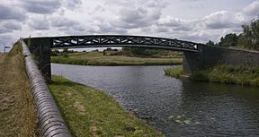
There's a special bridge at the junction. It's made of cast iron and connects the towpaths. The bridge was built when the Extension Canal was made. It's considered a historic structure and is protected as a grade II listed building.
 | Anna J. Cooper |
 | Mary McLeod Bethune |
 | Lillie Mae Bradford |


