Pembroke, Kentucky facts for kids
Quick facts for kids
Pembroke, Kentucky
|
|
|---|---|

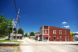
Main Street (KY 115)
|
|

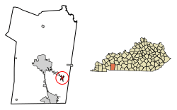
Location of Pembroke in Christian County, Kentucky.
|
|
| Country | United States |
| State | Kentucky |
| County | Christian |
| Incorporated | 1869 |
| Named for | a literary character |
| Area | |
| • Total | 1.12 sq mi (2.89 km2) |
| • Land | 1.11 sq mi (2.88 km2) |
| • Water | 0.01 sq mi (0.01 km2) |
| Elevation | 587 ft (179 m) |
| Population
(2020)
|
|
| • Total | 865 |
| • Density | 778.58/sq mi (300.74/km2) |
| Time zone | UTC-6 (Central (CST)) |
| • Summer (DST) | UTC-5 (CDT) |
| ZIP code |
42266
|
| Area code(s) | 270 & 364 |
| FIPS code | 21-59934 |
| GNIS feature ID | 0500368 |
Pembroke is a small city in Christian County, Kentucky, in the United States. It is known as a "home rule-class city," which means it has the power to govern itself on local matters.
In 2020, about 865 people lived in Pembroke. This number was very close to its population in 2010. Pembroke is also part of the larger Clarksville, Tennessee metropolitan area.
History of Pembroke
Pembroke was first settled in 1836. A local store owner named Dr. Lunsford Lindsay gave the town its name. He named it after a character called Pembroke Somerset, Esq. This character was from a book written in 1803 by Jane Porter, called Thaddeus of Warsaw.
Many years later, in 1869, Pembroke officially became an incorporated city. This meant it could set up its own local government.
Where is Pembroke Located?
Pembroke is found in the eastern part of Christian County. Its exact location is at 36°46′29″N 87°21′23″W.
A main road, U.S. Route 41, runs through the city. It's known as Nashville Street in Pembroke. This road goes about 9 miles (14 km) northwest to Hopkinsville, which is the main city of Christian County. If you go southeast on the same road, it leads about 14 miles (23 km) to Guthrie, near the Tennessee border.
The United States Census Bureau says Pembroke covers a total area of about 1.1 square miles (2.9 square kilometers). Most of this area is land. Only a tiny part, about 0.004 square miles (0.01 square kilometers), is water.
Pembroke's Population and People
| Historical population | |||
|---|---|---|---|
| Census | Pop. | %± | |
| 1870 | 278 | — | |
| 1880 | 202 | −27.3% | |
| 1890 | 466 | 130.7% | |
| 1900 | 654 | 40.3% | |
| 1910 | 731 | 11.8% | |
| 1920 | 685 | −6.3% | |
| 1930 | 775 | 13.1% | |
| 1940 | 570 | −26.5% | |
| 1950 | 531 | −6.8% | |
| 1960 | 517 | −2.6% | |
| 1970 | 634 | 22.6% | |
| 1980 | 636 | 0.3% | |
| 1990 | 640 | 0.6% | |
| 2000 | 797 | 24.5% | |
| 2010 | 869 | 9.0% | |
| 2020 | 865 | −0.5% | |
| U.S. Decennial Census | |||
In the year 2000, there were 797 people living in Pembroke. These people lived in 305 different homes. About 214 of these homes were families. The city had about 772 people per square mile (300 people per square kilometer).
Most of the people in Pembroke were White (about 64.87%). A significant number were African American (about 31.12%). Smaller groups included Native American, Asian, and people of two or more races. About 1.25% of the population identified as Hispanic or Latino.
Many homes (36.1%) had children under 18 living there. Almost half (48.2%) were married couples. About 18.4% of homes had a female head of household without a husband present. The average home had 2.45 people, and the average family had 2.95 people.
The median age in Pembroke was 37 years old. This means half the people were younger than 37, and half were older. About 25.7% of the population was under 18 years old. About 18.6% were 65 years or older.
In 2000, the median income for a household in Pembroke was $27,143 per year. For families, the median income was $30,568. This means half of the households earned more than this amount, and half earned less. About 24% of the population lived on lower incomes, including some children and older adults.
See also
 In Spanish: Pembroke (Kentucky) para niños
 | Janet Taylor Pickett |
 | Synthia Saint James |
 | Howardena Pindell |
 | Faith Ringgold |

