Pfaffenhofen (district) facts for kids
Quick facts for kids
Pfaffenhofen
|
||
|---|---|---|
|
||
| Country | ||
| State | Bavaria | |
| Adm. region | Upper Bavaria | |
| Region | Ingolstadt | |
| Capital | Pfaffenhofen an der Ilm | |
| Area | ||
| • Total | 760 km2 (290 sq mi) | |
| Population
(2000)
|
||
| • Total | 111,700 | |
| • Density | 147.0/km2 (380.7/sq mi) | |
| Time zone | UTC+1 (CET) | |
| • Summer (DST) | UTC+2 (CEST) | |
| Vehicle registration | PAF | |
| Website | landkreis-pfaffenhofen.de | |
Pfaffenhofen is a special kind of area in Bavaria, Germany, called a rural district (or Landkreis). It's like a county in other countries.
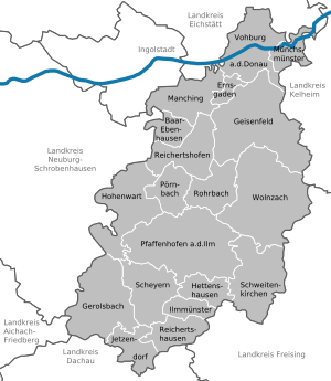
This district is located in the Hallertau Plains, which is a flat area between two important rivers: the Isar and the Danube. The big Danube river actually flows through the very northern part of the district.
Towns and Communities
The Pfaffenhofen district is made up of several towns and smaller communities. These places work together to manage the area.
Towns
- Geisenfeld
- Pfaffenhofen an der Ilm
- Vohburg
Communities
- Baar-Ebenhausen
- Ernsgaden
- Gerolsbach
- Hettenshausen
- Hohenwart
- Ilmmünster
- Jetzendorf
- Manching
- Münchsmünster
- Pörnbach
- Reichertshausen
- Reichertshofen
- Rohrbach
- Scheyern
- Schweitenkirchen
- Wolnzach
See also
 In Spanish: Distrito de Pfaffenhofen para niños
- Bavaria (the state where Pfaffenhofen is located)
- Rural districts of Germany (learn more about how these districts work)
Black History Month on Kiddle
Famous African-American Pilots:
 | Bessie Coleman |
 | Spann Watson |
 | Jill E. Brown |
 | Sherman W. White |

All content from Kiddle encyclopedia articles (including the article images and facts) can be freely used under Attribution-ShareAlike license, unless stated otherwise. Cite this article:
Pfaffenhofen (district) Facts for Kids. Kiddle Encyclopedia.


