
Phetchabun facts for kids
Quick facts for kids
Phetchabun
เพชรบูรณ์
|
|
|---|---|

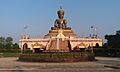
Phra Phuttha Maha Thammaracha
|
|

Phetchabun
Location in Thailand
|
|
| Country | Thailand |
| Provinces | Phetchabun Province |
| District | Mueang Phetchabun District |
| Elevation | 120 m (390 ft) |
| Population
(2005)
|
23,823 |
| Time zone | UTC+7 (ICT) |
| Website | http://www.nakornban.net/ |
Phetchabun is a town in Thailand. It is the main city of Phetchabun Province. The town is located along the Pa Sak River. In 2005, about 23,823 people lived there. Phetchabun is about 340 kilometers (211 miles) north of Bangkok, Thailand's capital.
Contents
What's in a Name? The Meaning of Phetchabun
People believe Phetchabun was started by two old kingdoms. These were the Sukhothai Kingdom and the Ayutthaya Period under King Narai. The province was first called "Phe-cha-buth." This name came from "Phuenchapura." It means 'town that grows plenty of crops.' This shows how fertile and good for farming the area is.
Phetchabun's Location and Landscape
Phetchabun is in a valley, which is a low area between hills. The Pa Sak River flows through the eastern part of the town. It runs from north to south. On both the east and west sides of Phetchabun, you can see the Phetchabun Mountains.
Phetchabun's Weather and Climate
Phetchabun has a tropical savanna climate. This means it has a dry season and a wet season. Winters are dry and very warm. Temperatures start to rise in April, which is usually very hot. The average high temperature can reach about 37.2 degrees Celsius (99 degrees Fahrenheit).
The monsoon season starts in late April and lasts until early October. During this time, there is a lot of rain. Days are a bit cooler, but nights stay warm.
| Climate data for Phetchabun (1991–2020) | |||||||||||||
|---|---|---|---|---|---|---|---|---|---|---|---|---|---|
| Month | Jan | Feb | Mar | Apr | May | Jun | Jul | Aug | Sep | Oct | Nov | Dec | Year |
| Record high °C (°F) | 37.6 (99.7) |
39.4 (102.9) |
42.2 (108.0) |
44.1 (111.4) |
43.4 (110.1) |
39.9 (103.8) |
37.8 (100.0) |
36.5 (97.7) |
36.0 (96.8) |
35.9 (96.6) |
37.2 (99.0) |
36.6 (97.9) |
44.1 (111.4) |
| Mean daily maximum °C (°F) | 32.5 (90.5) |
34.7 (94.5) |
36.7 (98.1) |
37.6 (99.7) |
35.5 (95.9) |
34.1 (93.4) |
32.9 (91.2) |
32.3 (90.1) |
32.5 (90.5) |
32.8 (91.0) |
32.7 (90.9) |
31.7 (89.1) |
33.8 (92.9) |
| Daily mean °C (°F) | 24.6 (76.3) |
26.5 (79.7) |
28.9 (84.0) |
30.1 (86.2) |
29.1 (84.4) |
28.7 (83.7) |
27.9 (82.2) |
27.5 (81.5) |
27.4 (81.3) |
27.2 (81.0) |
26.1 (79.0) |
24.4 (75.9) |
27.4 (81.3) |
| Mean daily minimum °C (°F) | 18.2 (64.8) |
19.9 (67.8) |
22.7 (72.9) |
24.6 (76.3) |
24.9 (76.8) |
24.8 (76.6) |
24.4 (75.9) |
24.3 (75.7) |
24.2 (75.6) |
23.2 (73.8) |
20.8 (69.4) |
18.4 (65.1) |
22.5 (72.6) |
| Record low °C (°F) | 8.5 (47.3) |
11.1 (52.0) |
12.1 (53.8) |
19.5 (67.1) |
21.4 (70.5) |
22.0 (71.6) |
21.5 (70.7) |
21.7 (71.1) |
19.6 (67.3) |
14.6 (58.3) |
8.5 (47.3) |
5.5 (41.9) |
5.5 (41.9) |
| Average precipitation mm (inches) | 10.8 (0.43) |
15.4 (0.61) |
50.7 (2.00) |
76.1 (3.00) |
168.0 (6.61) |
141.2 (5.56) |
160.1 (6.30) |
213.4 (8.40) |
210.0 (8.27) |
80.5 (3.17) |
12.0 (0.47) |
8.9 (0.35) |
1,147.1 (45.16) |
| Average precipitation days (≥ 1.0 mm) | 1.1 | 1.2 | 3.3 | 6.1 | 12.4 | 12.5 | 14.6 | 16.3 | 14.5 | 7.2 | 1.5 | 0.8 | 91.5 |
| Average relative humidity (%) | 74.4 | 76.2 | 77.5 | 76.2 | 76.1 | 75.7 | 76.3 | 76.4 | 79.8 | 81.5 | 75.9 | 71.9 | 76.5 |
| Mean monthly sunshine hours | 257.3 | 243.0 | 275.9 | 243.0 | 158.1 | 117.0 | 120.9 | 117.8 | 108.0 | 198.4 | 252.0 | 275.9 | 2,367.3 |
| Mean daily sunshine hours | 8.3 | 8.6 | 8.9 | 8.1 | 5.1 | 3.9 | 3.9 | 3.8 | 3.6 | 6.4 | 8.4 | 8.9 | 6.5 |
| Source 1: World Meteorological Organization | |||||||||||||
| Source 2: Office of Water Management and Hydrology, Royal Irrigation Department (sun 1981–2010)(extremes) | |||||||||||||
Getting Around Phetchabun
The main road that goes through Phetchabun is Route 21. This road connects Lom Sak in the north to Chai Badan and Saraburi in the south.
Phetchabun also has its own airport. Phetchabun Airport is about 29 kilometers (18 miles) north of the town.
Famous People from Phetchabun
- Saiphin Moore, a well-known Thai chef.
Images for kids
-
Phra Phuttha Maha Thammaracha, a famous Buddha statue.
