
Picture Canyon Natural and Cultural Preserve facts for kids
Quick facts for kids |
|
|
Picture Canyon Archeological Site
|
|
 |
|

Location in Arizona
|
|
| Location | El Paso Flagstaff Road, Flagstaff, Arizona |
|---|---|
| Area | 30 acres (12 ha) |
| NRHP reference No. | 07001349 |
| Added to NRHP | January 10, 2008 |
Picture Canyon is a super cool place in Flagstaff, Arizona! It's a nature preserve and an ancient archaeological site all in one. You can visit it any time of year to learn about nature, rocks, and old cultures, or just to have fun outdoors.
Contents
Discovering Picture Canyon's Past
Picture Canyon became a special protected place on January 10, 2008. It was added to the National Register of Historic Places. Later, in 2012, the City of Flagstaff bought this big 478-acre area. Many community groups worked hard for years to protect it.
A special agreement helps keep water flowing in the preserve. Water from a nearby treatment plant goes into a pond. This pond then feeds the Rio de Flag river. This constant water source helps the plants and animals that live along the river.
Thousands of years ago, from about 700 to 1300 AD, a group of native people lived here. They were called the Northern Sinagua, which means "people without water." Picture Canyon gets its name from the many petroglyphs they carved into the rocks. These ancient drawings are found all along the river. You can see hundreds of pictures showing archers, cool shapes, and local animals like birds and turtles.
Exploring Picture Canyon's Trails
Picture Canyon has three main trails for you to explore. They offer different ways to see the preserve's amazing features.
Tom Moody Trail
The Tom Moody Trail is a 2.8-mile loop that goes around the preserve. Near the start, there's an outdoor classroom with signs to teach you about the area. The trail first follows the Rio De Flag river. You can walk along the canyon walls and see a beautiful waterfall. If you keep going northeast and cross the Rio De Flag Bridge, you'll find a special spot with petroglyphs of waterbirds.
Don Weaver Trail
The Don Weaver Trail is shorter, about 0.7 miles long. It connects with the Tom Moody Trail to make a smaller loop. This trail takes you to the other side of the canyon. From here, you get another great view of the waterfall.
Arizona Trail Section
A 1.5-mile part of the Arizona Trail also runs through Picture Canyon. The full Arizona Trail is over 800 miles long! It stretches all the way from Mexico to Utah. This section of the Arizona Trail crosses the Tom Moody Trail inside the preserve.
Images for kids
-
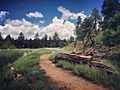
Tom Moody Trail
-
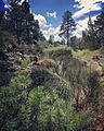
Don Weaver Trail
-
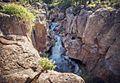
Waterfall - view from Tom Moody Trail
-
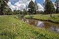
Meadow at the Rio De Flag bridge.


