
Pie Island facts for kids
| Geography | |
|---|---|
| Location | Lake Superior |
| Coordinates | 48°13′21″N 89°10′29″W / 48.22250°N 89.17472°W |
| Area | 46 km2 (18 sq mi) |
| Length | 12 km (7.5 mi) |
| Highest elevation | 438 m (1,437 ft) |
| Highest point | Le Pate mesa |
| Administration | |
|
Canada
|
|
| Province | Ontario |
| District | Thunder Bay |
| Demographics | |
| Population | uninhabited |
Pie Island, also known as Île Pâté in French, is a cool island in Lake Superior. It's about 12 kilometers (7.5 miles) long and covers 46 square kilometers. You can find it about 10 kilometers (6 miles) south of Thunder Bay, a city in Ontario, Canada. It's also about 25 kilometers (15 miles) north of Isle Royale National Park in Michigan. If you're in Thunder Bay, especially from higher spots, you can easily see Pie Island across the water!
In 1873, a local government was created for the areas around Thunder Bay. Pie Island became part of this new area, called the Municipality of Shuniah. It was part of a special section called Island Ward until 1936. After a long discussion about land ownership, which finished in 2011, much of the island was given back to the Fort William First Nation. There are also a few summer cottages on the southern tip of the island.
Contents
Le Pâté Mesa: The Island's Highest Point
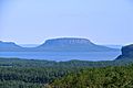
The English name 'Pie' comes from the French name Le Pâté, which means a meat pie with a crust. Le Pâté is the highest point on Pie Island. It's a type of flat-topped mountain called a mesa. This mesa was formed by a special rock layer called a diabase sill.
What is Le Pâté Mesa Like?
The mesa has steep cliffs on all sides and rises to 438 meters (1,460 feet) above sea level. Most of the top of the mesa is flat, but it slopes down towards the edges. There are also several deep valleys, called gullies, that cut across the mountaintop.
Plants on the Mesa
Because it's hard to reach the top of Le Pâté, the plants there have been able to grow naturally for a long time. Strong winds are a big reason why the plants on the mesa grow to a certain height and shape.
Mining and Farming on Pie Island
In the 1800s, people explored Pie Island a lot, looking for silver. A politician named Simon James Dawson even had a mine there. Later, a company called the Pie Island Silver Mining Company tried to find silver too. Another person, John McKellar, also mined on the island.
Early Farms on the Island
Around 1888, a lawyer named Francis Henry Keefer and his brother Thomas Keefer had a farm on the island. They grew hay there. Today, two places on the island, Keefer Point and Dawson Bay, are named after these important people.
The Pie Island Lighthouse
A lighthouse was first built on the west side of Pie Island in 1895. Lighthouses help guide ships safely. In 1904, the government moved the lighthouse to the north point of the island. This way, ships could see its light from much farther away.
The New Lighthouse
The original lighthouse was used until 1953 and was taken down in 2010. Now, there's a new, simpler light on a five-meter tall metal tower that still helps guide boats.
Fort William First Nation Land Claim
Pie Island is part of a land claim by the Fort William First Nation. This First Nation was promised reserve lands in the Robinson Treaty of 1850. In 1853, a government surveyor suggested that Pie Island should be part of their reserve, but this idea was not acted upon at the time.
Agreement Reached
Discussions between Canada, Ontario, and the Fort William First Nation started in 2000 and finished in December 2011. As a result, the province of Ontario transferred government-owned land on Flatland Island and Pie Island to the Fort William First Nation. This included the Le Pate Provincial Nature Reserve, which is 250 hectares (about 618 acres).
What the Agreement Means
Chief Peter Collins of the Fort William First Nation said that this agreement helps his community get the land and resources they need. He believes it will create new businesses, jobs, and other opportunities for their members and for the whole Thunder Bay area. He also said that the promises made in the 1850 Treaty about their reserve have finally been kept. As part of this agreement, Flatland Island, which is to the southeast, was also returned to the First Nation. However, privately owned land on the southern tip of Pie Island was not part of this land claim.
Images for kids
-
Le Pâté mesa

