Pine Valley, New Jersey facts for kids
Quick facts for kids
Pine Valley, New Jersey
|
|
|---|---|
|
Borough
|
|

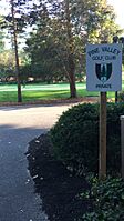
Sign for the Pine Valley Golf Club located in the former borough
|
|

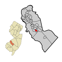
Pine Valley highlighted in Camden County. Inset: Location of Camden County highlighted in the State of New Jersey.
|
|

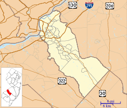
Census Bureau map of Pine Valley, New Jersey
|
|
| Country | |
| State | |
| County | Camden |
| Incorporated | April 23, 1929 |
| Disestablished | January 1, 2022 |
| Government | |
| • Type | Walsh Act |
| • Body | Board of Commissioners |
| Area | |
| • Total | 0.97 sq mi (2.51 km2) |
| • Land | 0.96 sq mi (2.47 km2) |
| • Water | 0.02 sq mi (0.04 km2) 1.55% |
| Area rank | 505th of 565 in state 28th of 37 in county |
| Elevation | 157 ft (48 m) |
| Population
(2020)
|
|
| • Total | 21 |
| • Estimate
(2021)
|
13 |
| • Rank | 563rd of 565 in state 36th of 37 in county |
| • Density | 22.0/sq mi (8.5/km2) |
| • Density rank | 561st of 565 in state 37th of 37 in county |
| Time zone | UTC−05:00 (Eastern (EST)) |
| • Summer (DST) | UTC−04:00 (Eastern (EDT)) |
| ZIP Code |
08021
|
| Area code(s) | 856 |
| FIPS code | 3400758920 |
| GNIS feature ID | 0885353 |
Pine Valley was a small town, also known as a borough, located in Camden County, New Jersey. It was known for being one of the smallest towns in New Jersey by population. In 2020, only 21 people lived there.
Pine Valley was home to the famous Pine Valley Golf Club. This golf course is often ranked as one of the best in America.
The Borough of Pine Valley was created on April 23, 1929. It was formed from a larger area called Clementon Township. Several other towns were also created on the same day.
In 2021, Pine Valley decided to join with its neighbor, the Borough of Pine Hill. This merger meant that Pine Valley's town government would no longer exist. The merger officially happened on January 1, 2022. Pine Hill gained the valuable golf club and more taxable property from this change. This was the first time two towns in New Jersey merged since Princeton did so in 2013.
Contents
Where is Pine Valley?
Pine Valley was a small area, covering about 0.97 square miles (2.51 square kilometers). Most of this area was land, with a small part being water.
The borough shared its borders with two other towns in Camden County: Clementon Borough and Pine Hill.
How Many People Lived There?
Pine Valley was always a very small town. Its population changed a bit over the years, but it remained one of the least populated places in New Jersey.
| Historical population | |||
|---|---|---|---|
| Census | Pop. | %± | |
| 1930 | 40 | — | |
| 1940 | 27 | −32.5% | |
| 1950 | 39 | 44.4% | |
| 1960 | 20 | −48.7% | |
| 1970 | 23 | 15.0% | |
| 1980 | 23 | 0.0% | |
| 1990 | 19 | −17.4% | |
| 2000 | 20 | 5.3% | |
| 2010 | 12 | −40.0% | |
| 2020 | 21 | 75.0% | |
| 2021 (est.) | 20 | 66.7% | |
| Population sources: 1930-2000 1930 1940–2000 2000 2010 2020 |
|||
In 2010, Pine Valley had only 12 residents, making it the second smallest town in New Jersey at that time. By 2020, the population grew slightly to 21 people.
Schools in the Area
Before the merger, Pine Valley had its own school district, but it didn't operate any schools. This meant that students from Pine Valley attended public schools in Haddonfield Public Schools. They went to school with students from Haddonfield and Tavistock, from pre-kindergarten all the way through high school.
The schools students attended included:
- Central Elementary School (grades K-5)
- Elizabeth Haddon Elementary School (grades K-5)
- J. Fithian Tatem Elementary School (grades PreK-5)
- Haddonfield Middle School (grades 6-8)
- Haddonfield Memorial High School (grades 9-12)
After the merger, students in the former Pine Valley area now attend schools in the Pine Hill Schools district, which includes Overbrook High School.
Getting Around Pine Valley
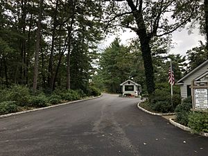
All the roads within Pine Valley were privately owned and maintained by the golf course. There was only one public way to enter the town, which was through Atlantic Avenue from the neighboring town of Pine Hill.
See also
 In Spanish: Pine Valley (Nueva Jersey) para niños
 | William L. Dawson |
 | W. E. B. Du Bois |
 | Harry Belafonte |


