Pintharuka, Western Australia facts for kids
Quick facts for kids PintharukaWestern Australia |
|
|---|---|

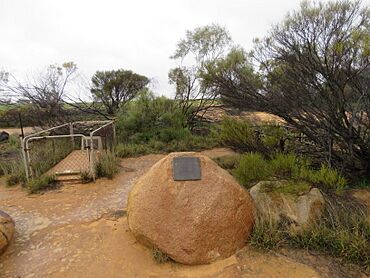
The historic Pintharuka cemetery in August 2022
|
|
| Established | 1913 |
| Postcode(s) | 6623 |
| Elevation | 303 m (994 ft) |
| Area | [convert: needs a number] |
| Location | |
| LGA(s) | Shire of Morawa |
| State electorate(s) | Moore |
| Federal Division(s) | Durack |
Pintharuka is a small, abandoned town in the Mid West region of Western Australia. It is located between the towns of Morawa and Mullewa. You can find it along the Mullewa-Wubin Road.
Contents
Pintharuka's History
How Pintharuka Started
In 1912, people were planning a new railway. This railway would connect Mullewa and Wongan Hills. A local group asked for a town to be built near a planned railway stop. This stop was called a siding.
The name "Pintharika" was chosen for the siding in 1913. Later that same year, the townsite was officially recognized. This means it became a real town on the map.
What's in a Name?
The name Pintharuka comes from a nearby well. This well was mapped out in 1910. The name itself is from the Aboriginal language. However, its exact meaning is not known today.
Life and Work in Pintharuka
Farming and Agriculture
The main work in the Pintharuka area was farming. Farmers grew cereal crops like wheat. They also raised animals, such as sheep. This type of farming is called agriculture.
In 1948, the town faced a big challenge. Heavy hail and rain caused floods. Many sheep were sadly lost during these violent thunderstorms.
Grain Storage and Transport
Pintharuka played an important role in storing grain. In 1932, the Wheat Pool of Western Australia made an announcement. They said Pintharuka would get two grain elevators. These elevators had engines to help move the grain. They were built right at the railway siding.
Today, Pintharuka is still a receival site for Cooperative Bulk Handling. This means it's a place where farmers can deliver their harvested grain.
 | Emma Amos |
 | Edward Mitchell Bannister |
 | Larry D. Alexander |
 | Ernie Barnes |


