Planchón-Peteroa facts for kids
Quick facts for kids Planchón-Peteroa |
|
|---|---|

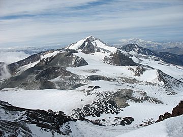
Peteroa as seen from the summit of Planchón.
|
|
| Highest point | |
| Elevation | 4,107 m (13,474 ft) |
| Geography | |
| Parent range | Andes |
| Geology | |
| Mountain type | Complex volcano |
| Last eruption | February to June 2011 |
Planchón-Peteroa is a huge volcano system. It sits right on the border between Argentina and Chile. This amazing place is actually made up of several volcanoes that have grown over many years. It also has some big, bowl-shaped areas called calderas. These calderas formed when parts of the volcanoes collapsed. The main volcanoes here are Volcán Planchón, Volcán Peteroa, and Volcán Azufre.
About 11,500 years ago, a large part of the volcano complex collapsed. This caused a massive landslide of rock and dirt. This landslide, called a debris avalanche, flowed down the Teno River. It traveled all the way to the Central Valley in Chile.
Peteroa volcano has a crater lake at its top. A crater lake is a lake that forms inside a volcanic crater. At the base of Planchón volcano, you can find Lagunas de Teno. The Vergara International Pass is also located in this area.
Volcano Eruptions
Planchón-Peteroa is an active volcano. This means it can erupt and release ash or lava. Scientists watch it closely to keep people safe.
2010 Eruption Activity
Planchón-Peteroa volcano erupted on September 6, 2010. A stronger eruption followed on September 18. On September 21, the volcano erupted again. This time, it sent a dark gray cloud of volcanic ash into the sky.
Winds carried the ash southeast into Argentina. Authorities warned people living nearby to leave their homes. This was a safety measure in case the volcano erupted again.
See also
- List of volcanoes in Argentina
- List of volcanoes in Chile
- Descabezado Grande
- Las Leñas
Learn More
- In Spanish: Volcán Peteroa para niños

 | Bessie Coleman |
 | Spann Watson |
 | Jill E. Brown |
 | Sherman W. White |


