Pleasant Plains, New Jersey facts for kids
Quick facts for kids
Pleasant Plains, New Jersey
|
|
|---|---|

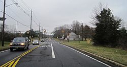
Looking south along South Middlebush Road (CR 615) approaching Claremont Road (CR 648)
|
|
| Country | |
| state | |
| County | Somerset |
| Township | Franklin |
| Area | |
| • Total | 3.22 sq mi (8.34 km2) |
| • Land | 3.21 sq mi (8.33 km2) |
| • Water | 0.01 sq mi (0.01 km2) 0.17% |
| Elevation | 95 ft (29 m) |
| Population
(2020)
|
|
| • Total | 792 |
| • Density | 246.35/sq mi (95.11/km2) |
| Time zone | UTC−05:00 (Eastern (EST)) |
| • Summer (DST) | UTC−04:00 (Eastern (EDT)) |
| Area code(s) | 609/640 and 732/848 |
| FIPS code | 34-59500 |
| GNIS feature ID | 02584018 |
Pleasant Plains is a small community in Franklin Township, New Jersey. It is known as an "unincorporated community." This means it's a recognized place but doesn't have its own separate local government. It is also a census-designated place (CDP), which is an area the U.S. Census Bureau defines for gathering population data.
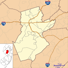
Pleasant Plains is located in Somerset County. It doesn't have clear borders, but it's generally found around the crossroads of South Middlebush Road and Claremont/Suydam Roads. In 2020, about 792 people lived here.
Contents
History of Pleasant Plains
Before 1998, Pleasant Plains was mostly made up of old farms. It had a very rural feel. In 1882, only about 46 people lived in the area.
Historic Buildings and Landmarks
Two important old buildings in Pleasant Plains are the former general store and blacksmith shop. These have been known as Laird's Brothers Hardware and Laird's Corner Store since the late 1800s. They are like a symbol of the area's past.
The Pleasant Plains Cemetery is another old landmark. It is on South Middlebush Road, near Laird's Corner. People have been buried there since the early days of the community.
The One-Room Schoolhouse
For many years, starting in the early 1800s, Pleasant Plains had a one-room schoolhouse. It was called the Pleasant Plains School. Children from the area learned there until around 1931. At that time, the township started using bigger schools instead of small one-room ones.
The old schoolhouse was moved across the road. It became a home for a while. Later, it was moved again to the Township's Municipal Complex. It is now waiting to be restored so people can learn about its history.
Six Mile Run Historic District
Some properties in the Pleasant Plains area are part of the Six Mile Run Historic District. This district is listed on both the New Jersey and National Register of Historic Places. This means these places are important for their history and are protected.
Geography of Pleasant Plains
Pleasant Plains covers an area of about 3.22 square miles (8.34 square kilometers). Most of this area is land. Only a very small part, about 0.01 square miles (0.014 square kilometers), is water.
Population and People
| Historical population | |||
|---|---|---|---|
| Census | Pop. | %± | |
| 2010 | 922 | — | |
| 2020 | 792 | −14.1% | |
| Population sources: 2010 2020 | |||
In 2010, the population of Pleasant Plains was 922 people. By 2020, the population was 792. The area is home to people from many different backgrounds.
Cemetery
The Pleasant Plains Cemetery is located on South Middlebush Road. It was officially started in 1898. It is a quiet place that shows the long history of the community.
See also
 In Spanish: Pleasant Plains (Nueva Jersey) para niños
 | John T. Biggers |
 | Thomas Blackshear |
 | Mark Bradford |
 | Beverly Buchanan |


