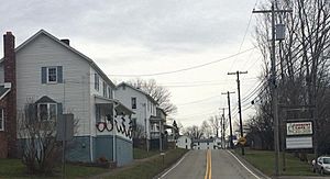
Pleasant Unity, Pennsylvania facts for kids
Quick facts for kids
Pleasant Unity, Pennsylvania
|
|
|---|---|
|
Unincorporated community
|
|

Pleasant Unity PA, near intersection of Route 981 and Route 130
|
|
| Country | United States |
| State | Pennsylvania |
| County | Westmoreland |
| Elevation | 1,083 ft (330 m) |
| Time zone | UTC-5 (Eastern (EST)) |
| • Summer (DST) | UTC-4 (EDT) |
| ZIP code |
15676
|
| Area code(s) | 724 |
| GNIS feature ID | 1184057 |
Pleasant Unity is a small, quiet community located in Westmoreland County, Pennsylvania. It's not a city or a town with its own government. Instead, it's an "unincorporated community" within Unity Township. This means it's part of a larger township area. You can find Pleasant Unity where two state roads, Route 130 and Route 981, meet. It's about 6.3 miles southeast of a bigger town called Greensburg.
Contents
Exploring Pleasant Unity
Where is Pleasant Unity?
Pleasant Unity is a community in Unity Township, Westmoreland County, Pennsylvania. It sits at the meeting point of state routes 130 and 981. This location is about 6.3 miles southeast of the city of Greensburg.
Mail and ZIP Codes
Pleasant Unity has its own post office. This post office uses the ZIP code 15676. It first opened a long time ago, on November 2, 1825. The area covered by this specific ZIP code is home to about 437 people. A ZIP code helps the postal service deliver mail to the correct address.
A Look at Its History
Coal Mining in the Past
From 1918 through the early 1960s, a company called Jamison Coal and Coke Company operated a mine near Pleasant Unity. This mine, known as Jamison No. 20, dug for bituminous coal underground. It was located off Route 981, about three miles north of the community.
The mining complex also had a company store. This store was found on Route 981 at Phillips Street. A special train line, the Unity Branch of the Pennsylvania Railroad, served the mine. It helped transport the coal. By the year 1940, about 300 miners worked at Jamison No. 20.
 | Laphonza Butler |
 | Daisy Bates |
 | Elizabeth Piper Ensley |


