Point MacKenzie, Alaska facts for kids
Quick facts for kids
Point MacKenzie, Alaska
|
|
|---|---|

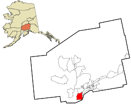
Location in Matanuska-Susitna Borough and the state of Alaska
|
|
| Country | United States |
| State | Alaska |
| Borough | Matanuska-Susitna |
| Area | |
| • Total | 164.79 sq mi (426.81 km2) |
| • Land | 162.33 sq mi (420.44 km2) |
| • Water | 2.46 sq mi (6.37 km2) |
| Elevation | 213 ft (65 m) |
| Population
(2020)
|
|
| • Total | 1,852 |
| • Density | 11.41/sq mi (4.40/km2) |
| Time zone | UTC-9 (Alaska (AKST)) |
| • Summer (DST) | UTC-8 (AKDT) |
| Area code(s) | 907 |
| FIPS code | 02-61788 |
| GNIS feature ID | 1865561 |
Point MacKenzie is a small community in Alaska, United States. It is known as a census-designated place (CDP), which means it's a special area set up by the government for counting people. Point MacKenzie is located in the Matanuska-Susitna Borough. It is also part of the larger Anchorage area. In 2020, about 1,852 people lived there. This was a big jump from 2010, when only 529 people lived in the area.
Contents
Where is Point MacKenzie?
Point MacKenzie is located in Alaska at 61°22′30″N 149°54′45″W / 61.37500°N 149.91250°W. It covers a total area of about 150.3 square miles (389.3 square kilometers). Most of this area is land, about 148.0 square miles (383.3 square kilometers). The rest, about 2.3 square miles (6.0 square kilometers), is water.
A Look at Point MacKenzie's Past
Point MacKenzie has an interesting history. Long ago, it was a trading spot for the Dena'ina Athabascans, who are Native Alaskan people. They called it Dilhi Tunch’del’usht Beydegh, which means "Point where we transport hooligan." This was a place where people from the Talkeetna Mountains would trade with the Dena'ina from the Knik Arm.
In the 1970s, there was a plan to build a new city called Seward's Success in this area. However, that plan never happened.
Who Lives in Point MacKenzie?
Point MacKenzie first appeared in the U.S. Census in 1960. Back then, it was called "McKenzie Point" and had only 25 people. It wasn't counted again until 2000, when it was officially named Point MacKenzie and became a census-designated place (CDP).
| Historical population | |||
|---|---|---|---|
| Census | Pop. | %± | |
| 1960 | 25 | — | |
| 2000 | 111 | — | |
| 2010 | 529 | 376.6% | |
| 2020 | 1,852 | 250.1% | |
| U.S. Decennial Census | |||
In 2000, there were 111 people living in Point MacKenzie. Most of the people were White (about 91.89%). There were also small numbers of Black or African American, Native American, and Asian people. Some people were from two or more races.
The community had 39 households. Many of these were families, with 61.5% being married couples living together. About 25.6% of households had children under 18. The average household had about 2.85 people.
The population in 2000 was spread out by age:
- 28.8% were under 18 years old.
- 29.7% were between 25 and 44 years old.
- 26.1% were between 45 and 64 years old.
- 7.2% were 65 years or older.
The average age in Point MacKenzie in 2000 was 38 years. For every 100 females, there were about 126.5 males.
See also
 In Spanish: Point MacKenzie (Alaska) para niños
 | Charles R. Drew |
 | Benjamin Banneker |
 | Jane C. Wright |
 | Roger Arliner Young |


