Port au Saumon River facts for kids
Quick facts for kids Port-au-Saumon River |
|
|---|---|

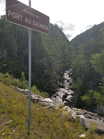
Seen upstream of the course of the "Salmon Port River" from the Highway 138 bridge
|
|
| Country | Canada |
| Province | Quebec |
| Region | Capitale-Nationale |
| Regional County Municipality | Charlevoix Regional County Municipality |
| City | La Malbaie |
| Physical characteristics | |
| Main source | Port-au-Saumon Lake La Malbaie 288 m (945 ft) 47°50′33″N 70°00′36″W / 47.84240°N 70.01013°W |
| River mouth | St. Lawrence River La Malbaie 0 m (0 ft) 47°45′19″N 69°57′13″E / 47.75528°N 69.95361°E |
| Length | 20.8 km (12.9 mi) |
| Basin features | |
| Tributaries |
|
The Port-au-Saumon River is a river in Quebec, Canada. It flows into the famous St. Lawrence River. This river is located in the town of La Malbaie, within the Charlevoix-Est Regional County Municipality.
The river's path ends at the St. Lawrence River in a small area called Port-au-Saumon. This spot is just northeast of the main town of La Malbaie.
Road 138, a major highway, runs along the lower part of the river's valley. Other local roads also help people get to different parts of the river.
The main activity in this area is forestry, which means managing forests and cutting trees. Tourism and fun activities, especially around Port-au-Saumon Lake, are also very popular.
The river usually freezes over from mid-December to late March. It's generally safe to walk or play on the ice from late December to mid-March.
Contents
River's Journey and Surroundings
The Port-au-Saumon River is surrounded by other rivers and bodies of water. Here are some of the main ones nearby:
- To the north: Port au Persil River, Noire River (Charlevoix)
- To the east: Port-au-Saumon Bay, St. Lawrence River
- To the south: Malbaie River, Comporté River
- To the west: rivière Noire Sud-Ouest, Jacob River
The Port-au-Saumon River starts at a lake called "Lac du Port-au-Saumon." This lake is shaped a bit like a clover and is surrounded by forests. Many people have vacation homes around the northern part of the lake. The river begins at the eastern end of the lake.
From the lake, the Port-au-Saumon River flows for about 20.8 kilometers (12.9 miles).
Upper Part of the River
The first part of the river's journey is about 15.1 kilometers (9.4 miles) long.
- It flows east, following a road, then turns southeast.
- It winds its way through the landscape, meeting smaller streams along the way.
Lower Part of the River
The last part of the river is about 5.7 kilometers (3.5 miles) long.
- It flows northeast, passing under the Sainte-Anne Rang Road Bridge.
- It goes through several rapids, which are fast-flowing sections of the river.
- It then passes under the Route 138 bridge.
- Finally, it flows southeast through more rapids before reaching Port-au-Saumon Inlet. This inlet connects to the Gulf of St. Lawrence. Two islands, Sabere and Camarine, are at the entrance of this bay.
River's Name
The name "Port-au-Saumon" is French. It refers to the bay, a small village, the river, and the lake. "Saumon" means "salmon" in French, suggesting that salmon might have been common here.
The name "Port-au-Saumon River" was officially recognized on December 5, 1968, by the Quebec Place Names Commission.
 | Shirley Ann Jackson |
 | Garett Morgan |
 | J. Ernest Wilkins Jr. |
 | Elijah McCoy |

