Portfield Hillfort facts for kids

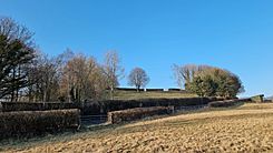
viewed from the southeast
|
|
| Lua error in Module:Location_map at line 420: attempt to index field 'wikibase' (a nil value). | |
| Location | Ribble Valley, Lancashire, England |
|---|---|
| Type | Hillfort |
| Length | 165 m (541 ft) |
| Width | 110 m (360 ft) |
| Area | c.1.4 ha (3.5 acres) |
| Height | 1.5 m (4 ft 11 in) |
| Site notes | |
| Excavation dates | 1957, 1960s, 1970s |
| Official name | Portfield hillfort |
| Designated | 9 October 1981 |
| Reference no. | 1013608 |
Portfield, also called Planes Wood Camp, is an ancient hillfort in Lancashire, Northern England. It is located near the town of Whalley. This fort was built a very long time ago, either in the late Bronze Age or the Iron Age.
It was first built with one main wall (called univallate). Later, it was changed to have more walls (called multivallate). This made it a stronger, small fort.
Contents
What is Portfield Hillfort?
Portfield Hillfort is a historic site that was once a fortified settlement. People lived here and used its strong walls for protection. It is now a protected Scheduled Ancient Monument. This means it is an important historical site that must be preserved.
Where is Portfield Located?
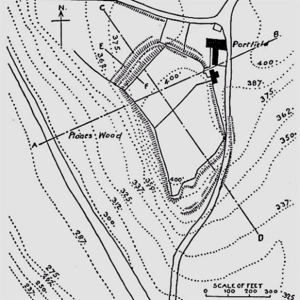
The hillfort sits on a small piece of land that sticks out, like a nose, over the River Calder valley. The land drops quickly down to the west. This made it a great spot for defence.
The main area of the fort is about 165 meters long and 110 meters wide. It looks like this area was flattened by people long ago. It was originally surrounded by a single wall, called a rampart. There was at least one way to get in on the north side. The whole site is a bit over 3.5 acres in size. It is about 400 feet above sea level.
How Was Portfield Protected?
The land around the fort slopes quite steeply. This was especially true on the southeast and northwest sides. On the western side, the slope is very steep, dropping about 50 feet. This natural steepness might have been enough protection, so no wall was needed there.
Today, the old walls are not in very good condition. But in the northwest corner, you can still see them best. Here, there are three layers of banks and ditches. These extra layers were likely added later to make the fort even stronger. They are about 1.5 meters high.
Discoveries at Portfield
Archaeologists have found many interesting things at Portfield. These discoveries help us understand who lived there and how they used the fort.
What Was Found During Excavations?
In the 1950s, a large water pipe, called the Haweswater Aqueduct, was built through the site. Because of this work, archaeologists did some digging in 1957. They found a paved path at the entrance and pottery from the 2nd century AD.
More discoveries were made in 1966. Workers laying another pipe found a hidden collection of nine Bronze Age objects. This included a gold bracelet and a special type of earring called a lock ring. More small digs in the 1960s and 1970s uncovered items from different time periods. These ranged from the Neolithic (New Stone Age) up to the Middle Ages.
What Does the Name Portfield Mean?
The name Portfield has been used for a farm near the site since at least the 16th century. The word 'port' might come from the Latin word portus. This word can mean a safe place or a refuge. This makes sense for a hillfort, which was a place of safety.
Why is Portfield Important?
Historic England is an organization that protects historic places. They consider Portfield to be a special and rare example in northwest England. It is one of the few hillforts that started with one wall and was later changed to have multiple walls. This shows how people adapted their defences over time.
 | Selma Burke |
 | Pauline Powell Burns |
 | Frederick J. Brown |
 | Robert Blackburn |


