
Powder House Island, Michigan facts for kids

USGS aerial imagery of Powder House Island
|
|

Powder House Island
Location in Wayne County, Michigan

Powder House Island
Location in Michigan

Powder House Island
Location in the United States
|
|
| Geography | |
|---|---|
| Location | Michigan |
| Coordinates | 42°06′26″N 83°08′09″W / 42.10722°N 83.13583°W |
| Highest elevation | 574 ft (175 m) |
| Administration | |
|
United States
|
|
| State | |
| County | Wayne |
Powder House Island is a small island located in the Detroit River. It is found in Wayne County, in the southeastern part of Michigan. Its exact location is 42°06′26″N 83°08′09″W / 42.10722°N 83.13583°W. In 1980, the United States Geological Survey measured its elevation as 574 ft (175 m) above sea level. This island has a unique history, especially linked to big construction projects in the area.
Contents
Where is Powder House Island?
Powder House Island is part of a group of islands in the Detroit River. This river connects Lake Erie and Lake St. Clair, forming an important waterway. The island is quite close to the city of Wyandotte. It sits near the border between the United States and Canada.
A Blast from the Past: Why "Powder House"?
The name "Powder House Island" gives us a big hint about its history. A "powder house" was a special building used to store explosives like gunpowder or dynamite. These materials needed to be kept very safely, away from other buildings. It's likely this island was chosen as a safe place to store explosives. These explosives were used for large construction jobs in the early 1900s.
Building the Livingstone Channel
One of the most important projects that used explosives was the creation of the Livingstone Channel. This channel is a deep shipping lane in the Detroit River. It was built to make it easier for large ships to travel through the river. Workers had to blast away rock and earth to create this deep path. Powder House Island probably served as a key storage spot for the dynamite needed for this massive undertaking. The channel was a huge engineering feat for its time.
An Explosion in 1906
During the construction of the Livingstone Channel, there was a notable event involving explosives. In 1906, a large amount of dynamite, about 800 lb (360 kg), exploded. This happened while workers were preparing the channel. Such incidents show how dangerous and challenging these early construction projects could be. The island's role in storing these materials was very important for safety.
Powder House Island Today
Today, Powder House Island remains in the Detroit River. It stands as a quiet reminder of the hard work and engineering that shaped the waterways of Michigan. The island's past is closely tied to the development of shipping routes. These routes are still vital for trade and transportation in the Great Lakes region.
Images for kids
-
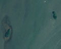
Powder House Island (right) and Fox Island (left) in a 2005 aerial photograph
-
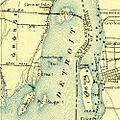
Powder House Island, as it appeared on a 1906 USGS map
-
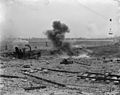
A 800 lb (360 kg) charge of dynamite being used for construction on the Livingstone Channel, in a photo taken between 1905 and 1920
-

1993 aerial photo, taken by USGS

,_1906,_1-62500_(cropped_to_Fox_and_Powder_House_Islands).jpg)


