Precita Creek facts for kids
Quick facts for kids Precita Creek |
|
|---|---|

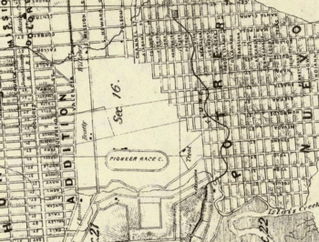
1861 Map of San Francisco showing the Precita Creek just south of the Pioneer Race Course
|
|
| Country | United States |
| State | California |
| Counties | City and County of San Francisco |
| City | San Francisco |
| Physical characteristics | |
| Main source | Market Street and 24th Street Near Bernal Heights, City and County of San Francisco, California 486 ft (148 m) 37°45′2.8″N 122°26′34.7″W / 37.750778°N 122.442972°W |
| River mouth | Islais Creek Near Islais Creek, City & County of San Francisco, California 30 ft (9.1 m) 37°44′58.31″N 122°23′50.262″W / 37.7495306°N 122.39729500°W |
| Length | 3 mi (4.8 km) |
Precita Creek was a small creek in the Bernal Heights and Mission District areas of San Francisco, California. Today, Precita Avenue follows the path where the creek used to flow. The creek got its name from precita, a Spanish word meaning dam or weir. The creek was covered up before the 1900s.
Contents
Where Precita Creek Flowed
Precita Creek started near Market Street and 24th Street. It flowed along what is now Precita Avenue and Cesar Chavez Street. The creek ended in a marshy area near Islais Creek. This area is close to where Cesar Chavez Street and Evans Avenue meet today.
History of Precita Creek
Early Days of the Creek
Precita Avenue was created along the creek's path around the early 1850s. By the 1860s, a small village grew up in the area now known as Precita Park. People in this village used the creek for their water. Sadly, they also used it as an open sewer, which means they put their waste directly into the creek.
Covering Up the Creek
Between the 1880s and the early 1900s, Precita Creek was paved over. This was done to create a new street called Army Street. Today, Army Street is known as Cesar Chavez Street. This means the creek now flows underground, hidden from view.


