Promontory Divide facts for kids
Quick facts for kids Promontory Divide |
|
|---|---|

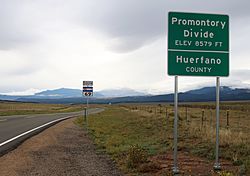
Looking south from the top of the pass along Colorado State Highway 69
|
|
| Elevation | 8,579 ft (2,615 m) |
| Traversed by | Colorado State Highway 69 |
| Location | Custer and Huerfano counties, Colorado |
| Coordinates | 37°56′16.26″N 105°19′37.25″W / 37.9378500°N 105.3270139°W |
| Topo map | Devils Gulch |
The Promontory Divide is a high point in southern Colorado, USA. It is a type of mountain pass, which means it's a lower area between mountains that people can travel through. This divide is 8,579 feet (about 2,615 meters) high.
It sits right on the border between two areas called Custer County and Huerfano County. A road called Colorado State Highway 69 goes right over this pass. You can find Promontory Divide in the southern part of the Wet Mountain Valley.
Water Flow and Rivers
The Promontory Divide acts like a natural split for water. Water on the north side of the pass flows into a stream called Antelope Creek. On the south side, water flows into Muddy Gulch. Muddy Gulch is a smaller stream that eventually joins the Huerfano River.
No matter which side the water starts on, it all ends up in the much larger Arkansas River. This shows how water travels across the land, connecting different areas.
 | James Van Der Zee |
 | Alma Thomas |
 | Ellis Wilson |
 | Margaret Taylor-Burroughs |


