Promontory Point (Chicago) facts for kids
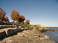
Promontory Point, often called The Point by locals, is a special piece of land built by people. It sticks out into Lake Michigan in Chicago. You can find it inside Burnham Park. The Point was made using filled-in land. By the late 1930s, a strong wall called a revetment was built to protect it from the lake. This wall was made by engineers from the Chicago Park District. It has four steps made of limestone blocks that lead down to a walking path.
On April 19, 2023, Promontory Point was named a Chicago Landmark. This means it's an important historical place in the city.
Contents
Exploring Promontory Point
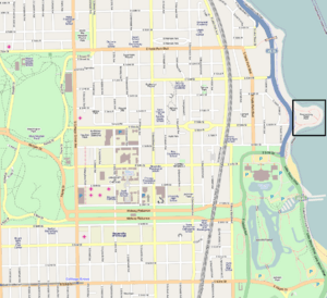
Promontory Point is located on land owned by the Chicago Park District at 55th Street. It's in Chicago's south side Hyde Park neighborhood. The park first opened to the public in 1937.
Park Design and Features
A landscape architect named Alfred Caldwell designed the park's look. He followed the Prairie School style, which uses plants and stones that are native to the area. Caldwell's design included a raised "meadow" in the middle of the 12-acre (about 48,500 square meters) peninsula. He also planted many flowering trees and shrubs.
In 1938, Caldwell created stone sitting rings around the lake's edge. These are called "council rings" and are still used today as fire pits. Not many of Caldwell's original plants are still there.
You can reach the park by using the Chicago Lakefront Trail. There's also a tunnel that goes under Lake Shore Drive at the east end of 55th Street. As you come out of the tunnel, you'll see the David Wallach Memorial Fountain. This fountain was designed in 1939 and looks like a fawn. It has drinking areas for both people and animals.
During the Cold War, the park had a 150-foot (about 46-meter) radar tower. This tower was part of the Nike Hercules missile defense system. It was taken down in 1971.
The Field House
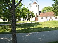
The park has a field house that was built in 1937. Its outside walls are made of Lannon stone from Wisconsin. Because of its amazing views of the lake and the city, it's a popular spot for weddings and other events.
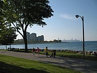
Many people gather at The Point to watch the summer fireworks from Navy Pier. This is especially true on Independence Day. The park is also close to the Museum of Science and Industry and the 57th Street Beach.
Water Activities
Access to the water is a big part of why people love The Point. Swimmers, sunbathers, kayakers, and windsurfers use the stone wall (revetment) to get into Lake Michigan. People have been swimming off these limestone steps since the park was built in 1937.
In summer, the north side of The Point becomes a "rock beach." The water there is shallow and sandy, making it a great place for families to swim. On both sides of The Point, open water swimmers enter the water from the rocks. They swim across the bays. During summer, "Swimming Area" buoys mark these swimming spots.
In the past, there were some disagreements with the Chicago Park District about swimming off The Point. Sometimes, swimmers even got tickets. But recently, the Chicago Park District created an official open water swimming area on the south side of The Point. No motorized boats are allowed inside these marked swimming areas.
Events at The Point
Even though some brave swimmers swim all year, there are special swimming events in spring and fall. These events happen on weekends near the summer solstice (longest day) and the autumnal equinox (equal day and night). They celebrate the swimming tradition and community at The Point.
The Spring Swim Around the Rocks happens every year on the Sunday after the summer solstice. The Fall Swim Around the Rocks takes place on the Sunday before the autumnal equinox. These events are open to everyone, and you don't need to sign up. Spectators watch from the shore. Swimmers enter the water using ladders on the south side. They then swim all the way around The Point to the shallow north side. Some swimmers then swim back to the ladders.
The Revetment
Much of Chicago's lakefront was created by filling in land. To protect these park areas, a seawall or revetment was built in the 1930s by the Chicago Park District. This revetment is made of large limestone blocks, each weighing 2 to 4 tons. These blocks are arranged like steps leading down to the lake.
The blocks are supported by a wooden structure filled with crushed rock. At the very edge of the revetment, wooden poles held together by a steel rail keep the limestone blocks from falling into the lake.
At The Point, the revetment has four steps that lead down to a 16-foot (about 5-meter) wide walking path. This revetment faces strong waves and was partly damaged by the early 1960s. A 1,000-foot (about 305-meter) section at the northeast tip of The Point was repaired. Workers removed the limestone blocks and poured a 3-foot (about 1-meter) thick concrete pad over the damaged wooden structure. This repair is still there today.
By the 1980s, the City of Chicago and the Chicago Park District started a project to fix the revetment along most of the city's lakefront. They got money from the U.S. Army Corps of Engineers. A study was done, and it concluded in 1993 that different parts of the revetment needed different kinds of repairs.
For Promontory Point, it was agreed that the repair would protect its historic look. This agreement was signed into a public contract and became law. It stated that the repairs should match the existing structure, following guidelines for historic preservation.
 | Jewel Prestage |
 | Ella Baker |
 | Fannie Lou Hamer |


