Puerto El Carmen de Putumayo facts for kids
Quick facts for kids
Puerto El Carmen de Putumayo
|
|
|---|---|
|
Town
|
|
 |
|
| Country | Ecuador |
| Province | Sucumbíos |
| Canton | Putumayo |
| Area | |
| • Town | 2.87 km2 (1.11 sq mi) |
| Population
(2022 census)
|
|
| • Town | 2,012 |
| • Density | 701.0/km2 (1,816/sq mi) |
| Climate | Af |
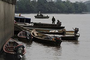
Puerto El Carmen de Putumayo is a town in Sucumbíos Province in Ecuador. It is also known as Puerto Carmen de Putumayo. This town is the main administrative center, or seat, of the Putumayo Canton.
The town is located right on the San Miguel River. It also has a small airport, called an airstrip. In 2022, about 2,012 people lived here. This means Puerto Putumayo has almost a quarter of the total population of the Putumayo Canton.
Puerto El Carmen de Putumayo is famous for being the easternmost town in Ecuador that you can reach by road. The national road E10 ends here. This road stretches nearly 450 kilometers from San Lorenzo, Esmeraldas. Even though it's the easternmost town reachable by road, the title of the absolute easternmost town goes to Nuevo Rocafuerte. That town is in the nearby Orellana Province. You can only get to Nuevo Rocafuerte by boat, much like other towns in the Amazon region of Peru. Puerto El Carmen de Putumayo is also on the same longitude as Tarapoto, Peru, which is 75 degrees West.
Climate in Puerto El Carmen de Putumayo
The climate in Puerto El Carmen de Putumayo is known as a tropical rainforest climate. This means it's generally hot and humid all year round. The average high temperatures are usually around 29 to 31 degrees Celsius (84 to 88 degrees Fahrenheit). The average low temperatures are around 20 to 21 degrees Celsius (68 to 70 degrees Fahrenheit).
This area receives a lot of rain throughout the year. Some months, like July, can get over 400 millimeters (about 15 inches) of rain. Even the driest months still get over 150 millimeters (about 6 inches) of rain. The air is also very humid, often around 82% to 87%.
| Climate data for Puerto El Carmen de Puyamayo, elevation 185 m (607 ft), (1971–2000) | |||||||||||||
|---|---|---|---|---|---|---|---|---|---|---|---|---|---|
| Month | Jan | Feb | Mar | Apr | May | Jun | Jul | Aug | Sep | Oct | Nov | Dec | Year |
| Mean daily maximum °C (°F) | 31.0 (87.8) |
31.0 (87.8) |
30.7 (87.3) |
30.4 (86.7) |
30.5 (86.9) |
29.6 (85.3) |
28.8 (83.8) |
29.6 (85.3) |
30.7 (87.3) |
30.9 (87.6) |
31.1 (88.0) |
31.5 (88.7) |
30.5 (86.9) |
| Mean daily minimum °C (°F) | 21.1 (70.0) |
21.0 (69.8) |
21.3 (70.3) |
21.2 (70.2) |
21.1 (70.0) |
20.9 (69.6) |
20.5 (68.9) |
20.6 (69.1) |
20.9 (69.6) |
21.0 (69.8) |
20.7 (69.3) |
21.2 (70.2) |
21.0 (69.7) |
| Average precipitation mm (inches) | 204.0 (8.03) |
177.0 (6.97) |
266.0 (10.47) |
326.0 (12.83) |
246.0 (9.69) |
332.0 (13.07) |
401.0 (15.79) |
283.0 (11.14) |
218.0 (8.58) |
257.0 (10.12) |
221.0 (8.70) |
151.0 (5.94) |
3,082 (121.33) |
| Average relative humidity (%) | 85 | 84 | 85 | 86 | 87 | 87 | 87 | 86 | 84 | 84 | 84 | 82 | 85 |
| Source: FAO | |||||||||||||
See also
 In Spanish: Puerto El Carmen de Putumayo para niños
 | Sharif Bey |
 | Hale Woodruff |
 | Richmond Barthé |
 | Purvis Young |


