Puerto San José facts for kids
Quick facts for kids
Puerto San José
|
|
|---|---|
|
Town
|
|

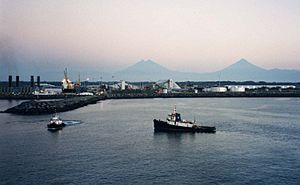
Puerto Quetzal seen at dawn, with the volcanoes on the horizon
|
|
| Country | |
| Department | Escuintla |
| Municipality | San José |
| Population | |
| • Total | 23,887 |
Puerto San José is a lively town located on the Pacific Ocean coast of Guatemala. It's part of the Escuintla area. In 2018, about 23,887 people lived there, making it the biggest town on Guatemala's Pacific coast.
This town used to be Guatemala's main Pacific port. However, in the 20th century, a new port called Puerto Quetzal was built. Puerto Quetzal is just four kilometers east of Puerto San José. Today, the Puerto Quetzal complex is the biggest employer for people living in the town.
Puerto San José is also a popular spot for tourists. Many people from Guatemala City visit on weekends to enjoy the coast. The San José Airport has been updated recently. It now serves as an official alternate airport for Guatemala City's main airport.
Climate and Weather in Puerto San José
Puerto San José has a tropical savanna climate. This type of climate is known as Aw in the Köppen system. It means the town experiences two main seasons each year.
Wet and Dry Seasons
The wet season in Puerto San José lasts from May to October. During these months, the town gets a lot of rain. The dry season runs from November to April. In these months, there is much less rainfall.
| Climate data for Puerto San José (San José Airport) (1991–2020) | |||||||||||||
|---|---|---|---|---|---|---|---|---|---|---|---|---|---|
| Month | Jan | Feb | Mar | Apr | May | Jun | Jul | Aug | Sep | Oct | Nov | Dec | Year |
| Record high °C (°F) | 38.7 (101.7) |
39.0 (102.2) |
40.3 (104.5) |
39.8 (103.6) |
39.2 (102.6) |
36.4 (97.5) |
36.6 (97.9) |
36.0 (96.8) |
35.6 (96.1) |
35.4 (95.7) |
35.2 (95.4) |
36.8 (98.2) |
40.3 (104.5) |
| Mean daily maximum °C (°F) | 32.6 (90.7) |
33.3 (91.9) |
34.2 (93.6) |
34.7 (94.5) |
33.6 (92.5) |
32.6 (90.7) |
32.9 (91.2) |
32.9 (91.2) |
32.0 (89.6) |
31.8 (89.2) |
32.3 (90.1) |
32.4 (90.3) |
32.9 (91.2) |
| Daily mean °C (°F) | 26.4 (79.5) |
27.1 (80.8) |
28.3 (82.9) |
29.4 (84.9) |
29.1 (84.4) |
28.5 (83.3) |
28.6 (83.5) |
28.4 (83.1) |
27.7 (81.9) |
27.5 (81.5) |
27.2 (81.0) |
26.6 (79.9) |
27.9 (82.2) |
| Mean daily minimum °C (°F) | 19.4 (66.9) |
19.9 (67.8) |
21.1 (70.0) |
22.7 (72.9) |
23.2 (73.8) |
23.2 (73.8) |
22.8 (73.0) |
22.9 (73.2) |
22.9 (73.2) |
22.7 (72.9) |
21.5 (70.7) |
20.2 (68.4) |
21.9 (71.4) |
| Record low °C (°F) | 12.3 (54.1) |
14.6 (58.3) |
14.6 (58.3) |
17.0 (62.6) |
18.9 (66.0) |
20.7 (69.3) |
19.4 (66.9) |
20.3 (68.5) |
20.7 (69.3) |
19.2 (66.6) |
15.8 (60.4) |
15.0 (59.0) |
12.3 (54.1) |
| Average precipitation mm (inches) | 0.9 (0.04) |
5.8 (0.23) |
10.2 (0.40) |
37.6 (1.48) |
197.0 (7.76) |
303.1 (11.93) |
233.2 (9.18) |
291.5 (11.48) |
289.6 (11.40) |
262.3 (10.33) |
64.5 (2.54) |
6.5 (0.26) |
1,702.2 (67.02) |
| Average precipitation days (≥ 1.0 mm) | 0.1 | 0.2 | 0.8 | 2.6 | 10.5 | 14.7 | 13.4 | 14.8 | 14.6 | 13.0 | 4.0 | 0.5 | 89.2 |
| Source: NOAA | |||||||||||||
See also
 In Spanish: Puerto San José para niños
 | Laphonza Butler |
 | Daisy Bates |
 | Elizabeth Piper Ensley |


