Puffin Island (Alaska) facts for kids
|
Native name:
Aġviat
|
|
|---|---|

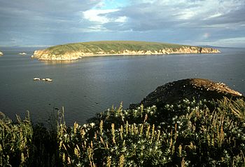
Puffin Island in the foreground, looking to Chamisso Island
|
|
| Geography | |
| Location | Arctic |
| Coordinates | 66°13′40″N 161°51′31″W / 66.22778°N 161.85861°W |
| Administration | |
|
United States
|
|
| State | Alaska |
| Demographics | |
| Population | 0 |
Puffin Island (in the Iñupiaq it's called Aġviat) is a small, rocky island in Alaska. It is found in a part of the Arctic known as the Kotzebue Sound. This island is located near Spafarief Bay and the mouth of Eschscholtz Bay. It sits just south of the Choris Peninsula.
Puffin Island is about 415 meters (or 454 yards) northwest of Chamisso Island. It is also about 58 miles (or 93 kilometers) southwest of Selawik. Even though Puffin Island is much smaller than Chamisso Island, it is home to many more nesting birds. You can find lots of horned puffins here!
About Puffin Island
Puffin Island is a steep, rocky place. It is located in the Northwest Arctic Borough of Alaska. The island's exact spot is 66°13′40″N 161°51′31″W / 66.22778°N 161.85861°W.
Both Puffin Island and Chamisso Island are part of a special protected area. This area is called the Chamisso Wilderness. It is part of the Chukchi Sea unit of the Alaska Maritime National Wildlife Refuge. This refuge helps protect many important wild places.
A Special Name
Puffin Island got its name in 1826. A British naval officer named Captain Frederick William Beechey named it. He wrote that there was a "steep rock" near Chamisso Island. He decided to call it Puffin Island to tell it apart from the other island. This name stuck, and it is still called Puffin Island today.
A Protected Home for Birds
Puffin Island has been a Natural Reserve since December 7, 1912. This means it is a protected area where nature can thrive. The Chamisso Wilderness includes Puffin Island, Chamisso Island, and some other small rocky islands nearby. This protection helps keep the islands safe for the many seabirds that live and nest there. It is especially important for the puffins and other birds that rely on these islands for their homes.
 | Jackie Robinson |
 | Jack Johnson |
 | Althea Gibson |
 | Arthur Ashe |
 | Muhammad Ali |

