Puka-Puka facts for kids
Quick facts for kids
Puka Puka
|
|
|---|---|

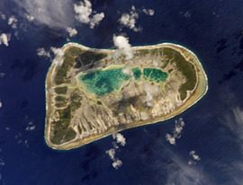
NASA picture of Puka-Puka Atoll
|
|

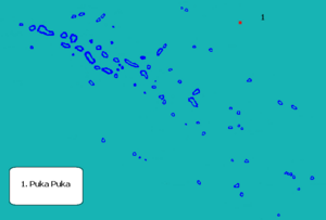
Location (in red) within the Tuamotu Archipelago
|
|
| Country | France |
| Overseas collectivity | French Polynesia |
| Subdivision | Îles Tuamotu-Gambier |
| Area
1
|
5 km2 (2 sq mi) |
| Population
(2017)
|
163 |
| • Density | 33/km2 (84/sq mi) |
| Time zone | UTC−10:00 |
| INSEE/Postal code |
98737 /
|
| 1 French Land Register data, which excludes lakes, ponds, glaciers > 1 km2 (0.386 sq mi or 247 acres) and river estuaries. | |

Puka-Puka is a small island made of coral. It is called an atoll. This atoll is in the northeast part of the Tuamotu Islands. Sometimes it is grouped with islands called the "Disappointment Islands."
Puka-Puka is very far from other places. The closest land is Fakahina, about 182 kilometers (113 miles) away to the southwest.
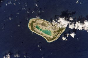
Puka-Puka Atoll is shaped like an oval. It is 6 kilometers (3.7 miles) long. Its widest part is 3.3 kilometers (2 miles). The land area is about 5 square kilometers (1.9 square miles). The water in the middle, called a lagoon, is now very small. It has filled up with dirt over time.
The low coral islands are dry. Not many people live there. In 2017, the total population was 163 people. The main town is Te One Mahina. About 110 people live in this town.
The language spoken on Puka-Puka is special. It is called Pukapukan. This language is different from what is spoken on most other Tuamotu islands. It is part of the Marquesic group.
Exploring Puka-Puka's Past
Puka-Puka was the first of the Tuamotu Islands seen by Europeans. This happened on January 21, 1521. The Spanish explorer Ferdinand Magellan and his team discovered it. They named it San Pablo. This was because they found it on the day Paul of Tarsus is said to have become a Christian. Magellan also found Flint Island, which he called Tiburones. He named both islands Islas Infortunadas, which means "Unfortunate Islands."
Later, on April 10, 1616, Dutch explorers arrived. Their names were Jacob le Maire and Willem Schouten. They were on a journey across the Pacific Ocean. They called Puka-Puka "Honden Eiland," which means "Dog Island."
On July 30, 1947, a famous explorer named Thor Heyerdahl passed by Puka-Puka. He was on a raft called the Kon Tiki. This was the first land he and his six-man team saw. They had sailed all the way from Callao, Peru.
In 1996, a strong typhoon hit the islands. It caused a lot of damage. But with help from France, the main town of Te One Mahina was rebuilt.
The Puka-Puka Airport was opened in 1979. This made it easier to travel to and from the island.
How Puka-Puka is Governed
Puka-Puka is also the name of a special area called an administrative commune. This is how the island is managed. Puka-Puka is the only atoll in this commune. The main office for the commune is in the village of Teone-Mahina.
See also
 In Spanish: Puka Puka (atolón) para niños
- List of reduplicated place names
 | Emma Amos |
 | Edward Mitchell Bannister |
 | Larry D. Alexander |
 | Ernie Barnes |

