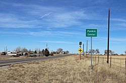
Punkin Center, Colorado facts for kids
Quick facts for kids
Punkin Center, Colorado
|
|
|---|---|

Looking north along State Highway 71 from a point south of its intersection with State Highway 94, November 2021
|
|
| Nickname(s):
Pumpkin Center
|
|
| Country | |
| State | |
| Counties | Lincoln |
| Elevation | 5,364 ft (1,635 m) |
| Time zone | UTC-7 (MST) |
| • Summer (DST) | UTC-6 (MDT) |
| ZIP codes | |
| Area code(s) | 719 |
Punkin Center is a small, rural place in Lincoln County, Colorado, United States. It's called an unincorporated community. This means it's not an official town or city with its own local government.
Punkin Center is located where two main roads meet: State Highway 94 and State Highway 71.
Contents
What is Punkin Center?
Punkin Center is a quiet spot in the countryside. It's known for its unique name and its history.
How Punkin Center Got Its Name
The story of Punkin Center's name goes back to 1920. A man named John Stevens built the first store there. It was a meeting point for farmers in the area.
John Stevens decided to paint all the new buildings a bright pumpkin color. This cheerful color inspired the name "Punkin Center."
A Look at Its History
Sadly, in the 1950s, a fire destroyed most of the buildings in Punkin Center. Even after the fire, the name stuck.
Today, Punkin Center is still a very small place. It has a few important features.
Modern Features
You can find communication towers near where the highways cross. These towers help with phone and internet signals in the area. There's also a larger tower about 3 miles southwest of the main intersection.
Even though Punkin Center is small, it has postal services. People living there get their mail through the Post Offices in nearby towns. These towns are Hugo (with ZIP Code 80821) and Ordway (with ZIP 81063).
 | Emma Amos |
 | Edward Mitchell Bannister |
 | Larry D. Alexander |
 | Ernie Barnes |


