Queen Charlotte Mountains facts for kids
Quick facts for kids Queen Charlotte Mountains |
|
|---|---|

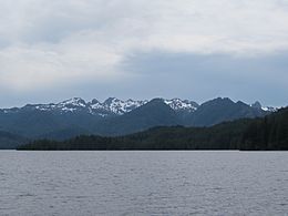
Yakoun Lake and the Queen Charlotte Range
|
|
| Highest point | |
| Peak | Mount Moresby |
| Elevation | 1,164 m (3,819 ft) |
| Geography | |
| Country | Canada |
| Province | British Columbia |
| Parent range | Insular Mountains |
The Queen Charlotte Mountains are a group of mountains found on Haida Gwaii, which are islands off the coast of British Columbia, Canada. These mountains are the northernmost part of a larger chain called the Insular Mountains.
The Queen Charlotte Mountains are divided into a few main parts. The Queen Charlotte Ranges cover a small area on the southwest side of Graham Island and most of Moresby Island. Another part is the Skidegate Plateau, which stretches across the middle of Graham Island and reaches the northeast tip of Moresby Island. To the northeast of the plateau is the Queen Charlotte Lowland, which is a flatter area.
The tallest mountain in the Queen Charlotte Mountains is Mount Moresby. It stands at about 1,164 m (3,819 ft) high.
Parts of the Queen Charlotte Mountains
The Queen Charlotte Mountains include several smaller mountain groups, often called sub-ranges. Here are some of them:
- Cameron Range: This range is located on the western side of Graham Island.
- Crease Range: You can find this range in the north-central part of Graham Island.
- McKay Range: This group of mountains is along the southern coast of Graham Island.
- San Christoval Range: This range is situated on the western side of Moresby Island.
 | Lonnie Johnson |
 | Granville Woods |
 | Lewis Howard Latimer |
 | James West |


