Río Abajo, Humacao, Puerto Rico facts for kids
Quick facts for kids
Río Abajo
|
|
|---|---|
|
Barrio
|
|

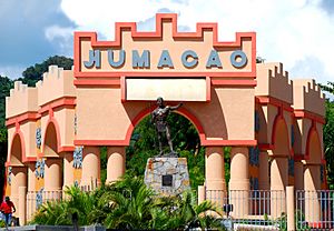
Taíno monument on pedestal in Río Abajo
|
|

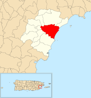
Location of Río Abajo within the municipality of Humacao shown in red
|
|
| Commonwealth | |
| Municipality | |
| Area | |
| • Total | 7.97 sq mi (20.6 km2) |
| • Land | 5.86 sq mi (15.2 km2) |
| • Water | 2.11 sq mi (5.5 km2) |
| Elevation | 7 ft (2 m) |
| Population
(2010)
|
|
| • Total | 7,495 |
| • Density | 1,279/sq mi (494/km2) |
| Source: 2010 Census | |
| Time zone | UTC−4 (AST) |
| ZIP Code |
00791
|
Río Abajo is a neighborhood, called a "barrio," located in the town of Humacao, Puerto Rico. In 2010, about 7,495 people lived there.
Contents
A Look at Río Abajo's Past
Puerto Rico became a territory of the United States after the Spanish–American War. This happened in 1898, following the Treaty of Paris of 1898.
In 1899, the U.S. government took a count of the people in Puerto Rico. They found that the combined population of Río Abajo and another barrio called Mambiche was 1,289 people.
How Río Abajo's Population Grew
The number of people living in Río Abajo has changed over the years. Here's how the population grew according to different counts:
- 1900: 1,289 people (this count included Mambiche barrio)
- 1980: 5,268 people
- 1990: 5,982 people
- 2000: 7,144 people
- 2010: 7,495 people
Understanding Flood Risks in Humacao
In 2019, new maps showed that Humacao is one of the most at-risk areas in Puerto Rico for flooding. This is because many hurricanes often enter the island near Humacao.
The town of Humacao has been working on plans to reduce flood damage. They shared that several of their coastal neighborhoods, including Río Abajo, are very likely to flood. These areas are also at risk of being badly damaged by a hurricane. Other neighborhoods facing similar risks are Antón Ruíz, Punta Santiago, Buena Vista, and Candelero Abajo.
Learn More
 In Spanish: Río Abajo (Humacao) para niños
 | Bayard Rustin |
 | Jeannette Carter |
 | Jeremiah A. Brown |


