Rainsville, Indiana facts for kids
Quick facts for kids
Rainsville, Indiana
|
|
|---|---|
| Country | United States |
| State | Indiana |
| County | Warren |
| Township | Pine |
| Founded | 1833 |
| Founded by | Isaac Rains |
| Area | |
| • Total | 0.21 sq mi (0.53 km2) |
| • Land | 0.21 sq mi (0.53 km2) |
| Elevation | 679 ft (207 m) |
| Population
(2020)
|
|
| • Total | 28 |
| • Density | 135.92/sq mi (52.45/km2) |
| Time zone | UTC-5 (Eastern (EST)) |
| • Summer (DST) | UTC-4 (EDT) |
| ZIP code |
47918
|
| Area code(s) | 765 |
| GNIS feature ID | 2806548 |
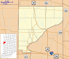
Rainsville is a very small unincorporated community located in Pine Township, Warren County, in the state of Indiana, United States. An unincorporated community means it doesn't have its own local government like a city or town.
Contents
A Look Back: Rainsville's History
Rainsville was officially planned and mapped out, a process called platting, on April 16, 1833. A man named Isaac Rains created the town. He had already built a mill there the year before. The community was named Rainsville in his honor.
A post office was opened in Rainsville on February 5, 1836. This allowed people to send and receive mail. However, the post office eventually closed its doors on September 15, 1904.
Where is Rainsville Located?
Rainsville is situated about 4 miles southwest of a place called Pine Village. It is also located about 2.5 miles east of U.S. Route 41, which is a major highway.
A stream called Big Pine Creek flows through the area. It starts near Pine Village, goes around the north side of Rainsville, and then continues flowing to the southwest.
Who Lives in Rainsville?
According to the 2020 United States Census, the population of Rainsville was 28 people. This shows it is a very small community.
| Historical population | |||
|---|---|---|---|
| Census | Pop. | %± | |
| 2020 | 28 | — | |
| U.S. Decennial Census | |||
Pictures of Rainsville
 | Emma Amos |
 | Edward Mitchell Bannister |
 | Larry D. Alexander |
 | Ernie Barnes |


