Ramtown, New Jersey facts for kids
Quick facts for kids
Ramtown, New Jersey
|
|
|---|---|

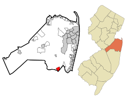
Location of Ramtown in Monmouth County highlighted in red (left). Inset map: Location of Monmouth County in New Jersey highlighted in orange (right).
|
|
| Country | |
| State | |
| County | Monmouth |
| Township | Howell |
| Area | |
| • Total | 2.18 sq mi (5.63 km2) |
| • Land | 2.16 sq mi (5.60 km2) |
| • Water | 0.01 sq mi (0.03 km2) 0.50% |
| Elevation | 59 ft (18 m) |
| Population
(2020)
|
|
| • Total | 6,329 |
| • Density | 2,924.7/sq mi (1,129.2/km2) |
| Time zone | UTC−05:00 (Eastern (EST)) |
| • Summer (DST) | UTC−04:00 (Eastern (EDT)) |
| Area code(s) | 732/848 |
| FIPS code | 34-61725 |
| GNIS feature ID | 02389724 |
Ramtown is a community in New Jersey, United States. It is located within Howell Township in Monmouth County. Ramtown is known as a census-designated place, or CDP. This means it is an area that looks like a town but does not have its own local government.
Ramtown's Location and Size
Ramtown is part of Howell Township. It is in Monmouth County, which is in the state of New Jersey. The United States Census Bureau says Ramtown covers about 2.2 square miles (5.63 square kilometers). Most of this area is land, with a very small part being water.
Who Lives in Ramtown?
| Historical population | |||
|---|---|---|---|
| Census | Pop. | %± | |
| 2000 | 5,932 | — | |
| 2010 | 6,242 | 5.2% | |
| 2020 | 6,329 | 1.4% | |
| Population sources: 2000-2010 2000 2010 2020 |
|||
In 2010, about 6,242 people lived in Ramtown. There were 1,924 homes, and most of these were families. The population density was about 2,847 people per square mile.
Most people living in Ramtown are White (91.53%). Other groups include Black or African American (2.84%) and Asian (2.77%). About 7.43% of the population was Hispanic or Latino.
Many homes in Ramtown have children under 18 (48%). Most families are married couples living together. The average household had about 3.24 people.
Schools in Ramtown
Ramtown has several schools that are part of the Howell Township Public Schools system. These schools are Ramtown Elementary, Greenville Elementary, and Howell Middle School South.
- Greenville Elementary serves students in kindergarten through second grade.
- Ramtown Elementary teaches students in third through fifth grades.
- Howell Middle School South is for students in sixth through eighth grades.
All three schools are close to each other, and students are provided with transportation. Not all students who attend these schools live in Ramtown itself. For example, some students from the Newbury area of Howell also go to Middle School South.
For high school, students in Ramtown attend one of three schools: Howell High School, Freehold Township High School, or Colts Neck High School. Which school they attend depends on where they live. These high schools are part of the Freehold Regional High School District. Students can also choose to join special programs offered at other high schools within this district.
See also
 In Spanish: Ramtown para niños
 | Anna J. Cooper |
 | Mary McLeod Bethune |
 | Lillie Mae Bradford |


